
Boutenac facts for kids
Quick facts for kids
Boutenac
|
||
|---|---|---|

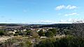
A general view of Boutenac
|
||
|
||

Boutenac
Location in France

Boutenac
Location in Occitanie
|
||
| Country | France | |
| Region | Occitanie | |
| Department | Aude | |
| Arrondissement | Narbonne | |
| Canton | Les Corbières | |
| Intercommunality | Région Lézignanaise | |
| Area
1
|
22.96 km2 (8.86 sq mi) | |
| Population
(Jan. 2019)
|
727 | |
| • Density | 31.664/km2 (82.01/sq mi) | |
| Time zone | UTC+01:00 (CET) | |
| • Summer (DST) | UTC+02:00 (CEST) | |
| INSEE/Postal code |
11048 /11200
|
|
| Elevation | 36–265 m (118–869 ft) (avg. 90 m or 300 ft) |
|
| 1 French Land Register data, which excludes lakes, ponds, glaciers > 1 km2 (0.386 sq mi or 247 acres) and river estuaries. | ||
_r%C3%A9el.svg)
Boutenac is a small and charming commune located in the south of France. A commune is like a local town or village area. As of January 2019, about 727 people live there.
Boutenac is part of the Occitanie region. This region is known for its beautiful landscapes. It is also in the Aude department. The Aude department is famous for its history and vineyards.
Contents
Where is Boutenac?
Boutenac is found in the southern part of France. It is located in the Narbonne arrondissement. An arrondissement is a type of administrative division in France. It helps organize local government.
What is a Canton?
The commune is also part of the Les Corbières canton. A canton is another way to divide areas in France. It groups several communes together. This helps with elections and local services.
Life in Boutenac
Boutenac is a quiet place. It has a total area of about 22.96 square kilometers. The land here varies in height. The lowest point is 36 meters above sea level. The highest point reaches 265 meters. This means there are some hills and valleys around the commune.
Local Government
Like all communes in France, Boutenac has a mayor. The mayor helps run the local government. They make decisions for the community. The mayor works with a council to manage things. These include local services and public spaces.
Images for kids
-
A general view of Boutenac
-
The coat of arms for Boutenac
See also
 In Spanish: Boutenac para niños
