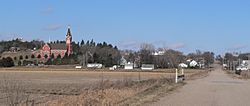
Bow Valley, Nebraska facts for kids
Quick facts for kids
Bow Valley, Nebraska
|
|
|---|---|
 |
|
| Country | |
| State | |
| County | Cedar |
| Area | |
| • Total | 0.14 sq mi (0.37 km2) |
| • Land | 0.14 sq mi (0.37 km2) |
| • Water | 0.00 sq mi (0.00 km2) |
| Elevation | 1,329 ft (405 m) |
| Population
(2020)
|
|
| • Total | 95 |
| • Density | 664.34/sq mi (257.02/km2) |
| ZIP code |
68739
|
| Area code(s) | 402 and 531 |
| FIPS code | 31-05980 |
| GNIS feature ID | 2583876 |
Bow Valley is a small, quiet community in Cedar County, Nebraska, United States. It's not an official town or city, but rather an unincorporated community. This means it doesn't have its own local government. Bow Valley is also part of a larger area called a census-designated place (CDP). This CDP includes the village and some surrounding areas. According to the 2020 census, about 95 people live in the Bow Valley CDP.
Contents
Where is Bow Valley Located?
Bow Valley is found in the northern part of Cedar County. It sits in a valley near West Bow Creek. This creek eventually flows into the big Missouri River.
How to Get There
If you're traveling by car, Nebraska Highway 12 passes about a mile north of Bow Valley. You can drive east on this highway for about 33 miles to reach Ponca. Going west for about 12 miles will take you to Crofton. Another road, Nebraska Highway 57, is about a mile west of Bow Valley. This highway goes south for about 6 miles to Hartington.
What is the Population of Bow Valley?
| Historical population | |||
|---|---|---|---|
| Census | Pop. | %± | |
| 2020 | 95 | — | |
| U.S. Decennial Census | |||
The number of people living in the Bow Valley area has changed over time. In 2020, the census showed that 95 people lived in the census-designated place of Bow Valley.
A Look at Bow Valley's Past
Bow Valley has a short but interesting history. It got its name from the valley it's located in.
When Was the Post Office Established?
A post office was first opened in Bow Valley way back in 1871. This was a very important place for people to send and receive letters and packages. However, the post office eventually closed down in 1907.
See also
 In Spanish: Bow Valley (Nebraska) para niños
 | Valerie Thomas |
 | Frederick McKinley Jones |
 | George Edward Alcorn Jr. |
 | Thomas Mensah |


