Boxholm, Iowa facts for kids
Quick facts for kids
Boxholm, Iowa
|
|
|---|---|

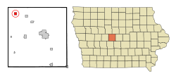
Location of Boxholm, Iowa
|
|
| Country | |
| State | |
| County | Boone |
| Township | Grant |
| Area | |
| • Total | 1.00 sq mi (2.60 km2) |
| • Land | 1.00 sq mi (2.60 km2) |
| • Water | 0.00 sq mi (0.00 km2) |
| Elevation | 1,145 ft (349 m) |
| Population
(2020)
|
|
| • Total | 181 |
| • Density | 180.46/sq mi (69.66/km2) |
| Time zone | UTC-6 (Central (CST)) |
| • Summer (DST) | UTC-5 (CDT) |
| ZIP code |
50040
|
| Area code(s) | 515 |
| FIPS code | 19-07750 |
| GNIS feature ID | 0454780 |
Boxholm is a small city in Boone County, Iowa, United States. It is located in Grant Township. In 2020, about 181 people lived there. Boxholm is part of a larger area that includes the cities of Boone and Ames.
Contents
History of Boxholm
Boxholm was officially planned and laid out in the year 1900. The town got its name from a place called Boxholm in Sweden. This was the home country of John B. Anderson, who was the first postmaster in Boxholm, Iowa. Many of the first people who settled in Boxholm were from Sweden.
The town held its first election for a town council in August 1913. Just one month later, Boxholm officially became an incorporated town. In 1963, the town celebrated its 50th anniversary, known as the Golden Anniversary. More than 1,200 people came to celebrate this special event.
Geography of Boxholm
Boxholm is located at 42°10′30″N 94°6′20″W / 42.17500°N 94.10556°W. This means it is in the northern part of the United States.
According to the United States Census Bureau, the city covers a total area of about 1.02 square miles (2.64 square kilometers). All of this area is land, with no large bodies of water inside the city limits.
People of Boxholm
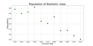
| Historical populations | ||
|---|---|---|
| Year | Pop. | ±% |
| 1920 | 296 | — |
| 1930 | 280 | −5.4% |
| 1940 | 285 | +1.8% |
| 1950 | 304 | +6.7% |
| 1960 | 250 | −17.8% |
| 1970 | 242 | −3.2% |
| 1980 | 267 | +10.3% |
| 1990 | 214 | −19.9% |
| 2000 | 215 | +0.5% |
| 2010 | 195 | −9.3% |
| 2020 | 181 | −7.2% |
| Source: and Iowa Data Center Source: |
||
2020 Census Information
In 2020, a total of 181 people lived in Boxholm. There were 85 households and 50 families. The city had about 180 people per square mile (69.7 per square kilometer). There were 106 housing units in total.
Most of the people in Boxholm, about 93.4%, were White. A small number were Black or African American (1.1%) or Native American (1.1%). About 3.3% of the people were from two or more racial backgrounds. No people identified as Hispanic or Latino in this census.
About 27.1% of the households had children under 18 living with them. Many households were married couples living together (38.8%). Some households had a female head with no spouse (21.2%), or a male head with no spouse (29.4%). About 32.9% of all households were made up of just one person. About 21.2% of households had someone living alone who was 65 years old or older.
The average age of people in Boxholm was 40.3 years. About 21.0% of residents were under 20 years old. About 27.1% were between 25 and 44 years old. And 18.2% were 65 years or older. The population was almost evenly split between males (50.8%) and females (49.2%).
2010 Census Information
In 2010, Boxholm had 195 people living in the city. There were 97 households and 54 families. The population density was about 191 people per square mile (73.8 per square kilometer). There were 109 housing units in total.
Most of the people (99.0%) were White. A very small number were African American (0.5%) or from other races (0.5%). About 1.5% of the population identified as Hispanic or Latino.
About 20.6% of households had children under 18. Many households were married couples (44.3%). About 38.1% of all households were made up of just one person. About 24.7% of households had someone living alone who was 65 years or older.
The average age in Boxholm in 2010 was 48.8 years. About 17.4% of residents were under 18. About 30.3% were 65 years or older. The population was also almost evenly split between males (51.3%) and females (48.7%).
Education in Boxholm
Students in Boxholm attend schools within the Southeast Valley Community School District. The main high school for this district is Southeast Valley High School, which is located in Gowrie.
Before 2023, Boxholm was part of the Southeast Webster-Grand Community School District. This district was formed in 2005 when the Grand Community School District and the Southeast Webster Community School District merged. In 2023, the Southeast Webster-Grand district joined with the Southeast Valley district.
At one time, Boxholm had its own elementary school for younger students.
See also
 In Spanish: Boxholm (Iowa) para niños
 | Isaac Myers |
 | D. Hamilton Jackson |
 | A. Philip Randolph |


