Boya, Western Australia facts for kids
Quick facts for kids BoyaPerth, Western Australia |
|||||||||||||||
|---|---|---|---|---|---|---|---|---|---|---|---|---|---|---|---|

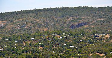
Boya from the south, Mountain Quarry and Greenmount Hill behind
|
|||||||||||||||
| Postcode(s) | 6056 | ||||||||||||||
| LGA(s) | Shire of Mundaring | ||||||||||||||
| State electorate(s) | Midland | ||||||||||||||
| Federal Division(s) | Hasluck | ||||||||||||||
|
|||||||||||||||
Boya is a small place in Western Australia, located on the Darling Scarp. This is a long, low ridge of hills. Boya is part of the Shire of Mundaring and sits near Greenmount Hill and Darlington.
The name Boya comes from the local Noongar language. It means "stone" or "rock". Government officials chose this name in the early 1900s.
Contents
Quarries: Digging for Stone
Boya was very important because of its stone quarries. Two big ones were the Mountain Quarry and the Government Quarry. They dug up a type of stone called blue stone.
Building Fremantle Harbour
Stone from the Government Quarry helped build the harbour and moles (long walls protecting the harbour) in Fremantle. This shows how important the stone from Boya was for big projects.
Quarry Names and Location
The Government Quarry had many names over time. It was sometimes called Mr O'Connor's quarry or the Public Works Quarry. Today, it is known as Hudman Road Quarry. This quarry is on the south-eastern side of Boya.
Bushfire Risks
Boya is close to the Greenmount National Park and the Hudman Road Quarry. Because of this, the area has faced serious bushfires in recent years. These fires often spread from the nearby park or quarry areas.
Railway History
Boya was once part of the early Eastern Railway line. This railway passed right through the area.
Cape Horn: A Tricky Curve
A famous spot on the railway in Boya was called "Cape Horn". It was a very sharp curve about 22-mile (35 km) from the start of the line. Trains sometimes went off the tracks here, especially if they were going too fast.
Homes in Boya
The houses in Boya look very different from each other. This is because the land is often steep and rocky. Builders had to be creative to build homes on these challenging blocks.
Transport Options
Bus Services
Boya has a bus service that helps people get around.
- The 322 bus goes from Midland Station to Glen Forrest. It stops along Scott Street, Marriott Road, and Coulston Road in Boya.
 | George Robert Carruthers |
 | Patricia Bath |
 | Jan Ernst Matzeliger |
 | Alexander Miles |

