
Bradley Land facts for kids
Bradley Land is the name given to a piece of land that Frederick Cook claimed he saw during an expedition in 1909. He said this land was located in the Arctic, between the positions (84°20′N 102°0′W / 84.333°N 102.000°W) and (85°11′N 102°0′W / 85.183°N 102.000°W). Cook described it as two landmasses separated by a break, which could have been a strait or an indentation. He named this land after John R. Bradley, who had helped fund Cook's journey.
What Cook Claimed to See
Frederick Cook published two photographs that he said showed Bradley Land. He described the lower part of the coast as looking similar to Axel Heiberg Island, with mountains and deep valleys. He estimated the upper coast to be about 300 meters (1,000 feet) high. He said it was flat and covered with a thin layer of ice.
The Truth About Bradley Land
Today, we know that there is no land at the location where Cook claimed to have seen Bradley Land. Scientists believe Cook's observations were either a mistake, where he confused sea ice for land, or that he simply made up the story. Cook's Inuit companions, who were with him on the expedition, later said that the photographs he published were actually taken near the coast of Axel Heiberg Island. This means Bradley Land was a "phantom island," a place once believed to exist but later found not to be real.
Images for kids
-
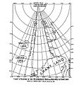
Map showing the location of Bradley Land sighted by Frederick Cook and Crocker Land sighted by Robert Peary.
-
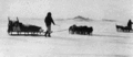
Photo of Cook's 1909 expedition, with alleged Bradley Land in background


See also
 In Spanish: Tierra de Bradley para niños
