Brandon Township, Michigan facts for kids
Quick facts for kids
Brandon Township, Michigan
|
|
|---|---|
|
Charter township
|
|
| Charter Township of Brandon | |

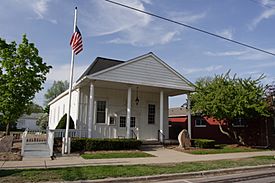
Brandon Township Hall
|
|

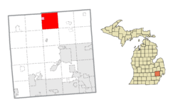
Location within Oakland County (red) and the administered village of Ortonville (pink)
|
|
| Country | United States |
| State | Michigan |
| County | Oakland |
| Established | 1837 |
| Area | |
| • Charter township | 35.98 sq mi (93.2 km2) |
| • Land | 35.11 sq mi (90.9 km2) |
| • Water | 0.87 sq mi (2.3 km2) |
| Elevation | 1,037 ft (316 m) |
| Population
(2020)
|
|
| • Charter township | 15,384 |
| • Density | 427.57/sq mi (165.086/km2) |
| • Metro | 4,296,250 (Metro Detroit) |
| Time zone | UTC-5 (EST) |
| • Summer (DST) | UTC-4 (EDT) |
| ZIP code(s) | |
| Area code(s) | 248 and 810 |
| FIPS code | 26-10040 |
| GNIS feature ID | 1625971 |
Brandon Charter Township is a special kind of township in Oakland County, Michigan. It's a place where many people live and work. In 2020, about 15,384 people called Brandon Township home.
This township is located north of Metro Detroit, which is a very large city area. It's about 30 miles (48.3 km) north of Detroit and 20 miles (32.2 km) southeast of Flint. A small village called Ortonville is also found inside Brandon Township.
Contents
History of Brandon Township
Brandon Township was officially created in 1837. It was named after the Town of Brandon in Vermont. Many of the first people who settled here came from that area. Later, in the 20th century, it became known as the Charter Township of Brandon.
Communities in Brandon Township
A "community" is a smaller area within the township where people live. Brandon Township has a few of these:
- Brandon Gardens is located near M-15 and Glass Road. Its elevation is about 971 feet (296 meters).
- Oakwood is on the eastern edge of the township, shared with Oxford Township. It's found at Baldwin and Oakwood Roads, with an elevation of 1099 feet (335 meters).
- Ortonville is a village that is completely surrounded by Brandon Township.
- Perry Lake Heights is located west of Perry Lake Road, near Perry Lake. It sits at an elevation of about 1030 feet (314 meters).
Geography of Brandon Township
Brandon Township covers a total area of about 35.98 square miles (93.19 km2). Most of this area is land, about 35.11 square miles (90.93 km2). The rest, about 0.87 square miles (2.25 km2), is water. This means there are lakes, rivers, or streams within the township.
People Living Here
In 2000, there were 14,765 people living in Brandon Township. There were about 5,012 households, which are groups of people living together in one home. Many of these households, about 45%, had children under 18 living with them.
The people living in the township are of all ages. About 30.6% were under 18 years old. Around 35.2% were between 25 and 44 years old. About 5.5% of the population was 65 years or older. The average age of people living here was 35 years old.
Education
Most of the students in Brandon Township go to schools in the Brandon School District. If you live in this area, your high school would be Brandon High School. However, a small part of the eastern township is part of Oxford Community Schools. Students from that area would attend Oxford High School.
See also
 In Spanish: Municipio de Brandon (Míchigan) para niños
 | John T. Biggers |
 | Thomas Blackshear |
 | Mark Bradford |
 | Beverly Buchanan |


