Branford, Florida facts for kids
Quick facts for kids
Branford, Florida
|
|
|---|---|
| Town of Branford | |

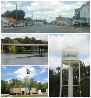
Top, left to right: Downtown Branford, Suwannee River, Branford Town Hall, Branford Water Tower
|
|
| Motto(s):
"On the Banks of the Suwannee River"
"Spring Diving Capital of the World" "In God We Trust" |
|

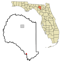
Location in Suwannee County and the state of Florida
|
|
| Country | |
| State | |
| County | Suwannee |
| Settled (Rowland's Bluff-New Branford Settlement) | 1886 |
| Incorporated | 1961 |
| Government | |
| • Type | Mayor-Council |
| Area | |
| • Total | 1.14 sq mi (2.94 km2) |
| • Land | 1.14 sq mi (2.94 km2) |
| • Water | 0.00 sq mi (0.00 km2) |
| Elevation | 39 ft (12 m) |
| Population
(2020)
|
|
| • Total | 711 |
| • Density | 625.88/sq mi (241.72/km2) |
| Time zone | UTC-5 (Eastern (EST)) |
| • Summer (DST) | UTC-4 (EDT) |
| ZIP code |
32008
|
| Area code(s) | 386 |
| FIPS code | 12-08175 |
| GNIS feature ID | 0279335 |
Branford is a small town in Suwannee County, Florida, in the United States. It's known for being on the banks of the Suwannee River. The town was officially started in 1961, but people have lived there since 1882.
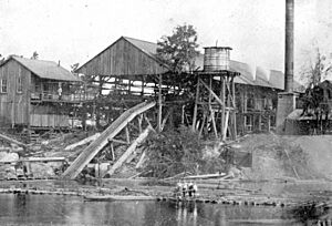
It was first called Rowland's Bluff in the 1870s. Back then, it had a sawmill and a ferry to cross the Suwannee River. In 1882, a railroad came to Branford. The town was then named New Branford, after a town in Connecticut. Later, the "New" was dropped. A big hurricane damaged the town in 1896, but it was rebuilt quickly. In 2020, about 711 people lived in Branford.
Contents
Where is Branford Located?
Branford is located in Florida, right on the banks of the Suwannee River. You can find it at these coordinates: 29°57′42″N 82°55′38″W / 29.96167°N 82.92722°W.
Two main roads, U.S. Route 27 and U.S. Highway 129, meet in Branford. The town covers an area of about 1.14 square miles (2.94 square kilometers), and all of it is land.
What is Branford's Climate Like?
The weather in Branford is usually hot and humid in the summer. Winters are generally mild. This type of weather is called a humid subtropical climate.
How Many People Live in Branford?
Branford is a small town. In 2020, the population was 711 people.
Here's how the population has changed over the years:
| Historical population | |||
|---|---|---|---|
| Census | Pop. | %± | |
| 1890 | 335 | — | |
| 1910 | 26 | — | |
| 1920 | 708 | 2,623.1% | |
| 1930 | 498 | −29.7% | |
| 1940 | 684 | 37.3% | |
| 1950 | 753 | 10.1% | |
| 1960 | 663 | −12.0% | |
| 1970 | 820 | 23.7% | |
| 1980 | 622 | −24.1% | |
| 1990 | 670 | 7.7% | |
| 2000 | 695 | 3.7% | |
| 2010 | 712 | 2.4% | |
| 2020 | 711 | −0.1% | |
| U.S. Decennial Census | |||
In 2020, there were 323 households in the town. In 2010, there were 712 people and 345 households.
Schools in Branford
The schools in Branford are part of the Suwannee County School District.
- Branford Elementary School
- Branford High School
Branford Library
The Branford Library is part of the Suwannee River Regional Library System. This system has eight branches and also serves Hamilton and Madison counties. The library is open six days a week on Suwannee Avenue.
Branford Springs: A Fun Diving Spot
Branford Springs is a popular place for diving. It's located right within the town, on the Suwannee River. Many people enjoy exploring the underwater world here.
See also
 In Spanish: Branford (Florida) para niños
 | Audre Lorde |
 | John Berry Meachum |
 | Ferdinand Lee Barnett |


