Bras Saint-Nicolas facts for kids
Quick facts for kids Bras Saint-Nicolas |
|
|---|---|

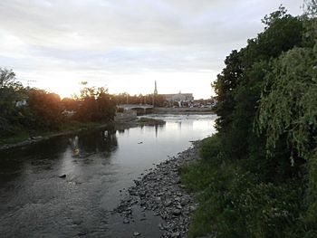
Confluence of the Bras Saint-Nicolas with the rivière du Sud (Montmagny) at Montmagny.
|
|
| Country | Canada |
| Province | Quebec |
| Region | Chaudière-Appalaches |
| MRC | Montmagny Regional County Municipality |
| Physical characteristics | |
| Main source | Agricultural streams Sainte-Apolline-de-Patton 361 metres (1,184 ft) 46°54′59″N 70°15′15″W / 46.916343°N 70.254113°W |
| River mouth | Rivière du Sud (Montmagny) Montmagny 10 metres (33 ft) 46°58′47″N 70°33′16″W / 46.97972°N 70.55444°W |
| Length | 45.5 kilometres (28.3 mi) |
| Basin features | |
| Progression | Rivière du Sud (Montmagny), St. Lawrence River |
| Tributaries |
|
The Bras Saint-Nicolas is a river in Quebec, Canada. It's like a smaller arm that flows into a bigger river called the rivière du Sud (Montmagny). The rivière du Sud then flows into the mighty St. Lawrence River.
This river travels through several towns and areas in Quebec. These include Sainte-Apolline-de-Patton, Cap-Saint-Ignace, Saint-Cyrille-de-Lessard, Saint-Eugène, Notre-Dame-de-Bonsecours, and Montmagny. It's all part of the Montmagny Regional County Municipality in the Chaudière-Appalaches region.
Contents
What is the Bras Saint-Nicolas River Like?
Where Does the River Start?
The Bras Saint-Nicolas river begins in a place called Sainte-Apolline-de-Patton. It starts where two smaller streams, the Méchant Pouce River and Fortin stream, meet. This starting point is near a small village called "L'Espérance." It's also on the northern side of the Notre Dame Mountains.
How Long is the River?
From its start, the Bras Saint-Nicolas flows for about 45.5 kilometers (that's about 28 miles). It winds its way through different landscapes.
What Rivers are Nearby?
The main areas that drain water into or near the Bras Saint-Nicolas are called watersheds.
- To the north, you'll find the St. Lawrence River and the Tortue River (L'Islet).
- To the east, there's the rivière des Perdrix and the Trois Saumons River.
- To the south, you'll see the Cloutier River and the rivière du Sud (Montmagny).
- To the west, it's mainly the rivière du Sud (Montmagny).
Where Does the River End?
The Bras Saint-Nicolas river eventually joins the rivière du Sud (Montmagny). This meeting point is in the heart of the town of Montmagny. It's located near the Route 132 bridge.
How Did the Bras Saint-Nicolas Get Its Name?
The name "Bras Saint-Nicolas" has an interesting history. "Bras" means "arm" in French, referring to it being an arm of a larger river.
Connecting to Early Settlers
One idea is that the name comes from Nicolas Gamache. He was an early settler who received land along the river in 1672. This land was given to him by an important official named Jean Talon.
Another idea links the name to Nicolas Després. His daughter, Geneviève Després, was married to Louis Couillard de Lespinay. Louis bought the land area of Rivière-du-Sud in the 1650s.
When Was the Name First Used?
Maps from the early 1800s show the river with a similar name.
- In 1802, a map by Samuel Holland showed it as "R. St. Nicholas'."
- In 1803, another map by Vondenvelden used "Bras."
- In 1815, Joseph Bouchette also used "Bras" to describe it as a branch of a waterway.
The name "Bras Saint-Nicolas" was officially recognized on December 5, 1968. This was done by the Commission de toponymie du Québec, which is the official body for place names in Quebec.
Bridges Over the Bras Saint-Nicolas
Many bridges cross the Bras Saint-Nicolas river. These bridges help people and vehicles get from one side to the other. They are important parts of the local transportation network.
Some of the notable bridges include:
- The Bridge 05076 in Cap-Saint-Ignace, built in 1939.
- The Pierre-Noël Bridge in Saint-Cyrille-de-Lessard, built in 1952.
- The Bernier Bridge in L'Islet, which is quite old, built in 1891.
- Several bridges carry Highway 20 over the river in Cap-Saint-Ignace.
- The Railway bridge in Montmagny carries the Canadian National Railway tracks.
- The Bridge 10810 on Cloutier Street in Montmagny, also built in 1891.
These bridges show how the river has been an important part of the landscape for a long time, connecting communities.
 | Toni Morrison |
 | Barack Obama |
 | Martin Luther King Jr. |
 | Ralph Bunche |


