Rivière du Sud (Montmagny) facts for kids
Quick facts for kids Rivière du Sud |
|
|---|---|
 |
|
| Country | Canada |
| Province | Quebec |
| Region | Chaudière-Appalaches |
| Regional County Municipality | Montmagny Regional County Municipality |
| Physical characteristics | |
| Main source | Forested streams Notre-Dame-du-Rosaire 440 m (1,440 ft) 46°51′03″N 70°20′06″E / 46.850956°N 70.334979°E |
| River mouth | Saint Lawrence River Montmagny 4 m (13 ft) 46°59′10″N 70°33′03″W / 46.98611°N 70.55083°W |
| Length | 86.5 km (53.7 mi) |
| Basin features | |
| Tributaries |
|
The Rivière du Sud (which means River of the South in English) is a river in Quebec, Canada. It's a major tributary that flows into the southern side of the big Saint Lawrence River. This river travels through several towns in the Montmagny Regional County Municipality, making its way through beautiful landscapes in the Chaudière-Appalaches region.
River's Journey
The Rivière du Sud starts its journey in a forest and mountain area. Its source is in Notre-Dame-du-Rosaire, about 25 kilometers (15.5 miles) southeast of Montmagny. The river begins high up, at an elevation of about 440 meters (1,444 feet).
How the River Flows
From its source, the South River flows for about 86.5 kilometers (53.7 miles). Along its path, the river drops about 436 meters (1,430 feet) in height.
- Upper Part of the River: In its upper section, the river flows mostly southwest. It passes by the Montagne aux Érables and collects water from smaller streams like the Fraser River and the Alick River. It also flows through Notre-Dame-du-Rosaire and Sainte-Euphémie-sur-Rivière-du-Sud.
- Middle Part of the River: As it continues, the river turns more to the west and then northwest. It picks up more water from rivers like the rivière à la Loutre, the rivière du Pin, and the Fourche River. It also flows near the village of Armagh and collects water from the Noire River.
- Lower Part of the River: In its final section, the river turns north and then northeast. It passes through Saint-Raphaël, Saint-François-de-la-Rivière-du-Sud, and Saint-Pierre-de-la-Rivière-du-Sud. It also collects water from the Bras Saint-Michel and the Morigeau River.
Where the River Ends
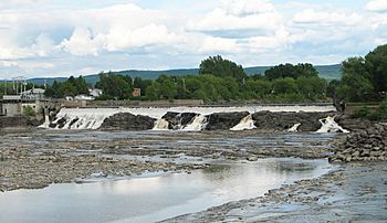
The Rivière du Sud eventually reaches the town of Montmagny. Here, it flows over a 7-meter (23-foot) waterfall before joining the huge Saint Lawrence River. This meeting point is special because it includes a bird sanctuary in Montmagny.
River's Name
The name "Rivière du Sud" means "River of the South." It's thought that Samuel de Champlain, a famous explorer, might have called it "S. Antoine river" on his map in 1632. Later, in 1641, it appeared on another map as "Grande Rivière du Sud" (Great River of the South).
The name "Rivière du Sud" became official when land was granted to Charles Huault de Montmagny in 1646. The name has stayed the same ever since. You can see how important this river is because three towns it flows through are named after it: Saint-Pierre-de-la-Rivière-du-Sud, Saint-François-de-la-Rivière-du-Sud, and Sainte-Euphémie-sur-Rivière-du-Sud.
The name "Rivière du Sud" was officially recognized on December 5, 1968, by the Commission de toponymie du Québec, which is like a naming committee for places in Quebec.
Related Articles
- Saint Lawrence River
- Notre-Dame-du-Rosaire
- Sainte-Euphémie-sur-Rivière-du-Sud
- Armagh
- Saint-Raphaël
- Saint-François-de-la-Rivière-du-Sud
- Saint-Pierre-de-la-Rivière-du-Sud
- Montmagny
- Montmagny Regional County Municipality
- List of rivers of Quebec
 | Georgia Louise Harris Brown |
 | Julian Abele |
 | Norma Merrick Sklarek |
 | William Sidney Pittman |

