Brawlin, New South Wales facts for kids
Quick facts for kids BrawlinNew South Wales |
|
|---|---|

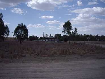
Brawlin – with disused rail siding at left background
|
|
| Postcode(s) | No postcode |
| Elevation | 295 m (968 ft) |
| Location |
|
| LGA(s) | Gundagai Council |
| County | Harden |
| State electorate(s) | Cootamundra |
| Federal Division(s) | Hume |
Brawlin is a small community located in the Riverina region of New South Wales, Australia. It's found in the northeastern part of the Riverina. This quiet spot is about 12 kilometres south of Cootamundra. It is also about 29 kilometres north of Coolac.
Contents
Exploring Brawlin
Brawlin is a small, peaceful place. It's known for its quiet rural setting. The community is part of the Gundagai Council area.
Where is Brawlin Located?
Brawlin is situated in a rural area. It's part of the Harden County. The nearest larger towns are Cootamundra and Coolac. It is also 110 kilometres from Wagga Wagga. Sydney is about 362 kilometres away.
A Glimpse into Brawlin's Past
Brawlin has a bit of history tied to its past services. A Post Office once operated here. It opened on 1 February 1880. However, it closed many years later in 1951.
Brawlin was also home to a railway siding. A railway siding is a short track next to a main railway line. It is used for loading and unloading goods. This siding is no longer in use today.
How to Find Brawlin
Finding Brawlin requires a bit of local knowledge. You won't find it on a main highway. To reach Brawlin, you need to take a specific dirt road. This road is called the Brawlin to Lockhart dirt road. It runs west from the main road that connects Coolac to Cootamundra.
 | Ernest Everett Just |
 | Mary Jackson |
 | Emmett Chappelle |
 | Marie Maynard Daly |


