Breaker Bay facts for kids
Quick facts for kids
Breaker Bay
|
|
|---|---|
|
Suburb
|
|

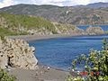
Breaker Bay, the bay after which the suburb is named, looking east
|
|

Breaker Bay, outlined in blue, sits at the Wellington Harbour entrance.
|
|
| Country | New Zealand |
| Local authority | Wellington City |
| Electoral ward | Motukairangi/Eastern Ward |
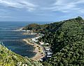
Breaker Bay is a cool suburb located on the southeast coast of Wellington City in New Zealand. It's part of the Miramar Peninsula. This area is named after its big, 600-meter-wide bay.
Contents
Exploring Breaker Bay's Geography
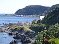
Breaker Bay is a narrow piece of land. It stretches along the southeast coast of the Miramar Peninsula. The suburb has five bays. The biggest one is Breaker Bay itself. As you go south, you'll find Eve Bay, Flax Bay, Reef Bay, and Palmer Bay. This area is also part of the western side of the Wellington Harbour entrance.
Why is it Called Breaker Bay?
The suburb gets its name from its largest bay. In 1948, a writer named F. L. Irvine-Smith explained the name. She said "Breaker Bay" is a very fitting name. This is because waves often crash there. You reach the bay through a place called the Pass of Branda. This pass is named after a famous pass in Scotland.
Dealing with Strong Winds and Waves
Breaker Bay is known for its strong southerly winds. It faces the Cook Strait, which can be very windy. In winter, big waves often crash over the road. Strong storms can also cause problems. They put a lot of pressure on the coastline. This can lead to erosion, where the land wears away.
For example, in 2013, a storm damaged the only road. It became unusable for a time. In 2016, work started on a new seawall. This wall helps protect houses and the road. It was finished in April 2017. Another big storm hit in 2021. It was so bad that a state of emergency was declared. About 140 homes in Breaker Bay had to be evacuated. The road was closed for about a day. Workers had to clear a lot of debris from the road.
Remembering the Wahine Disaster
The Wahine disaster happened near Breaker Bay. This was a sad event in 1968. A ferry sank, and 53 people lost their lives. The ferry ended up on Barrett Reef. This reef is a rocky area just off the bay. Stuart Young, who lived in Breaker Bay, was the first to call for help. Some residents tried to go out in small boats. But the waves were too strong, and they had to turn back.
Today, there's a special place to remember this event. It's called the Wahine Memorial Park. The park is near where some survivors reached the shore. It even has a part of the ship, called a bow thruster.
Enjoying Nature and Views
The Eastern Walkway runs along the top of the bay. It offers amazing views of the area. You can often spot dolphins swimming in the water. Orca are also seen regularly from the suburb. Penguins nest in the area too. You might even see "penguin crossing" signs on the road! These signs help protect the penguins.
Getting Around Breaker Bay
Breaker Bay has only one main road. It's called Breaker Bay Road. This road runs very close to the coast. A commuter bus (No 30x) serves the suburb. It runs on weekdays. In the mornings, it goes to the city. In the afternoons, it heads back to the beach.
Images for kids
-
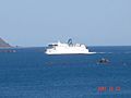
A ferry arriving in Wellington from Picton, seen from Breaker Bay.
-
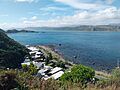
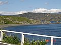
Breaker Bay seen from Ataturk Memorial Park.
-
-
-
-
-
-