Brenda, Arizona facts for kids
Quick facts for kids
Brenda, Arizona
|
|
|---|---|

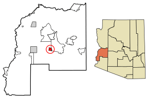
Location of Brenda in La Paz County, Arizona
|
|
| Country | United States |
| State | Arizona |
| County | La Paz |
| Area | |
| • Total | 6.91 sq mi (17.90 km2) |
| • Land | 6.91 sq mi (17.90 km2) |
| • Water | 0.00 sq mi (0.00 km2) |
| Elevation | 1,375 ft (419 m) |
| Population
(2020)
|
|
| • Total | 466 |
| • Density | 67.44/sq mi (26.04/km2) |
| Time zone | UTC-7 (Mountain (MST)) |
| Area code(s) | 928 |
| GNIS feature ID | 24335 |
| FIPS code | 04-07590 |
Brenda is a small community in La Paz County, Arizona, United States. It is known as a census-designated place (CDP). This means it's an area defined by the government for counting people, but it doesn't have its own city government.
Where is Brenda, Arizona?
Brenda is located in the western part of Arizona. It is about 10 miles (16 kilometers) east of a town called Quartzsite. You can find Brenda about 4 miles (6.4 kilometers) northeast of Interstate 10, a major highway. The community is right on U.S. Route 60 (US 60).
Brenda is also close to some interesting natural areas. It lies about 5 miles (8 kilometers) east of the Plomosa Mountains. It is also the closest community to the New Water Mountains Wilderness. This wilderness area is a protected natural space, located about five air miles to the south. Brenda is the last community you'll find on US 60 if you're traveling west.
How Many People Live in Brenda?
The number of people living in Brenda changes over time. Every ten years, the United States government counts everyone in the country. This is called the U.S. Census.
Here's how Brenda's population has changed:
- In 2010, there were 676 people living in Brenda.
- In 2020, the population was 466 people.
Brenda was first recognized as a census-designated place (CDP) in the 2010 U.S. Census.
See also
 In Spanish: Brenda (Arizona) para niños
 | John T. Biggers |
 | Thomas Blackshear |
 | Mark Bradford |
 | Beverly Buchanan |


