Bridgeman Island (South Shetland Islands) facts for kids

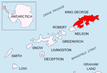
Location of King George Island in the South Shetland Islands
|
|
|
Location of Bridgeman Island
|
|
| Geography | |
|---|---|
| Location | Antarctica |
| Coordinates | 62°04′S 56°44′W / 62.067°S 56.733°W |
| Archipelago | South Shetland Islands |
| Length | 0.8 km (0.5 mi) |
| Highest elevation | 240 m (790 ft) |
| Administration | |
| Administered under the Antarctic Treaty System | |
| Demographics | |
| Population | Uninhabited (although there are some weather stations) |
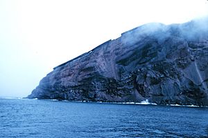
Bridgeman Island is a small, round island in the South Shetland Islands. It is a volcano that rises steeply from the sea. The island is about 0.8 kilometers (0.5 miles) long and 240 meters (787 feet) high. It lies about 37 kilometers (23 miles) east of King George Island.
Bridgeman Island is located in Antarctica at coordinates 62°04′S, 56°44′W. Its name has been used since around 1820. The island is actually what's left of a much bigger volcano that is now mostly underwater. This old volcano doesn't show signs of recent activity. Some old reports from the 1800s about steam vents (fumaroles) might have actually been about the much younger Penguin Island nearby.
Contents
What is Bridgeman Island?
Bridgeman Island is part of the South Shetland Islands, a group of islands near the Antarctic Peninsula. It's a volcanic island, meaning it was formed by a volcano. Even though it's a volcano, it's not active anymore. The island is quite small and has very steep sides.
How was Bridgeman Island Formed?
Bridgeman Island is the top part of a very large stratovolcano. A stratovolcano is a tall, cone-shaped volcano built up by many layers of hardened lava, ash, and rocks. This volcano is located within an area called the Bransfield Basin. The base of this underwater volcano is about 25 kilometers (15.5 miles) wide. Its total height from the seafloor is about 1050 meters (3,445 feet).
The island itself is the remains of this much larger volcano. Over a very long time, parts of the volcano have been worn away by wind and water, leaving only the top section visible above the ocean. This process is called erosion.
Is Bridgeman Island Inhabited?
No, Bridgeman Island is not inhabited by people. It is a very remote and cold place. However, there are some weather stations in the South Shetland Islands that help scientists study the weather and climate in this part of the world.
Why is Bridgeman Island Important?
Bridgeman Island is important for scientists who study volcanoes and geology. It gives them clues about how volcanoes form and change over time, especially in cold, polar regions. Studying islands like Bridgeman helps us understand Earth's history and its geological processes.
See also
 In Spanish: Isla Bridgeman para niños
 | Delilah Pierce |
 | Gordon Parks |
 | Augusta Savage |
 | Charles Ethan Porter |


