Brighton Township, Michigan facts for kids
Quick facts for kids
Brighton Township, Michigan
|
|
|---|---|
|
Charter township
|
|
| Charter Township of Brighton | |

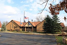
Brighton Township Hall on Buno Road
|
|

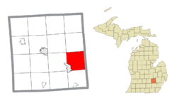
Location within Livingston County
|
|
| Country | United States |
| State | Michigan |
| County | Livingston |
| Established | 1838 |
| Area | |
| • Total | 34.6 sq mi (89.6 km2) |
| • Land | 33.0 sq mi (85.4 km2) |
| • Water | 1.6 sq mi (4.2 km2) |
| Elevation | 945 ft (288 m) |
| Population
(2020)
|
|
| • Total | 19,144 |
| • Density | 581/sq mi (224.2/km2) |
| Time zone | UTC-5 (Eastern (EST)) |
| • Summer (DST) | UTC-4 (EDT) |
| ZIP Codes | |
| Area code(s) | 810 |
| FIPS code | 26-10640 |
| GNIS feature ID | 1625982 |
Brighton Charter Township is a special kind of local government area called a charter township. It is located in Livingston County in the state of Michigan, United States. In 2020, about 19,144 people lived here. The township is next to the city of Brighton. Even though they are close, they are managed separately.
Contents
Exploring Brighton Township
Brighton Township is a great place to learn about Michigan's geography and communities. It has a mix of natural areas and important landmarks.
Local Communities and History
- The city of Brighton is right next to the township. It has its own government and is not part of the township.
- Pleasant Valley was a small, old post office in the southeast part of the township. It operated a long time ago, from 1837 to 1852.
Where is Brighton Township?
Brighton Township is in the southeastern part of Livingston County. It shares a border with Oakland County to the east.
Major Roads and Travel
Two big highways, Interstate 96 and U.S. Route 23, meet in the southwest part of the township.
- I-96 has several exits in the township. It can take you east about 43 miles to Detroit or west about 47 miles to Lansing.
- US 23 connects to I-96 here. It goes north about 36 miles to Flint and south about 17 miles to Ann Arbor.
Land and Water Features
Brighton Township covers about 89.6 square kilometers (about 34.6 square miles). Most of this area is land (85.4 square kilometers), and a smaller part (4.2 square kilometers) is water. The streams and rivers in the township flow towards the west and southwest. They are part of the Huron River system, which eventually flows into Lake Erie.
Important Landmarks
The Milford Proving Ground is a large testing facility for cars. It is located in the northeast part of Brighton Township.
Who Lives in Brighton Township?
In 2000, there were 17,673 people living in Brighton Township. The population density was about 533.7 people per square mile. Most people living here are from a White background. Many residents have family roots from countries like Poland, Ireland, England, or Germany.
Family Life and Age Groups
Many families live in Brighton Township. About 42.9% of households had children under 18 living with them. Most households (76.0%) were married couples. The average household had almost 3 people.
The population has different age groups:
- About 30% of the people were under 18 years old.
- About 6.7% were 65 years old or older.
- The average age of people in the township was 38 years old.
Learning in Brighton Township
Students in Brighton Township attend several different schools.
Public Schools
Most students go to schools in the Brighton Area Schools district or the Hartland Consolidated Schools district.
Private Schools
There are also several private schools in the area:
- St. Patrick's Catholic School is a traditional Catholic school. It includes religious teachings in its lessons.
- Shepherd of the Lakes Lutheran School and Cornerstone Christian School are other Christian schools.
- Charyl Stockwell Academy (for younger students) and Charyl Stockwell Preparatory Academy (for middle and high school students) are part of the Stockwell District.
See also
 In Spanish: Municipio de Brighton (Míchigan) para niños


