
Bristol Island facts for kids

South Sandwich Islands
|
|

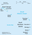
Location of Bristol Island
|
|
| Geography | |
|---|---|
| Location | Antarctica |
| Coordinates | 59°02′S 026°31′W / 59.033°S 26.517°W |
| Length | 8 km (5 mi) |
| Administration | |
|
United Kingdom
|
|
Bristol Island is an island that is about 8 kilometers (5 miles) long. It lies in the middle of Montagu Island and Thule Island, which are all part of the South Sandwich Islands. In Spanish, it's sometimes called Isla Blanco or Isla Blanca.
This island is special because it's the only land you'll find on the 59th parallel south, which is an imaginary line of latitude around the Earth.
Contents
What is Bristol Island Like?
Bristol Island has many interesting natural spots. Some of these include Harker Point, Fryer Point, Turmoil Point, and Trulla Bluff. You can also find Havfruen Peak, Mount Sourabaya, and Mount Darnley there. The island is also surrounded by rocks like Grindle Rock, Wilson Rock, and Freezland Rock.
Active Volcanoes
Bristol Island is actually made up of several active volcanoes! This means they can erupt. People have reported eruptions happening in 1823, 1935, 1936, 1950, 1956, and most recently in 2016.
History of Bristol Island
Bristol Island was first discovered in 1775 by a British journey led by James Cook. He named the island to honor a naval officer named Augustus Hervey, 3rd Earl of Bristol.
The very first time someone landed on the island was in 1908. This landing was made by a captain named Carl Anton Larsen.
Who Owns Bristol Island?
Bristol Island is not inhabited by people. It is managed by the United Kingdom as a British Overseas Territory. This means it's a territory that belongs to the UK but is not part of the UK itself. It is part of the South Georgia and the South Sandwich Islands group.
However, Argentina also claims Bristol Island as part of its own territory. This claim is part of a larger disagreement over islands in the South Atlantic. Even with this claim, Argentina did not try to take over the island during the Falklands War.
Images for kids
-
Bristol Island
-
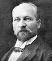
Captain Carl Anton Larsen


See also
 In Spanish: Isla Blanco (Sandwich del Sur) para niños
