
Thule Island facts for kids

NASA Terra ASTER image of Thule Island
|
|

Location of Thule Island
|
|
| Geography | |
|---|---|
| Coordinates | 59°27′S 27°18′W / 59.450°S 27.300°W |
| Archipelago | South Sandwich Islands |
| Area | 5.5 km2 (2.1 sq mi) |
| Highest elevation | 3,525 ft (1,074.4 m) |
| Administration | |
|
United Kingdom
|
|
| South Georgia and the South Sandwich Islands | |
| Demographics | |
| Population | Uninhabited |
Thule Island, also known as Morrell Island, is a small, remote island in the South Sandwich Islands. It is one of the southernmost islands in this group, which is part of a cluster called Southern Thule. The island got its name from a legendary place called Thule. Ancient mapmakers believed Thule was at the very edge of the world.
The island's other name, Morrell Island, honors Benjamin Morrell. He was an American explorer and a captain who hunted whales. The famous explorer James Cook and his crew on the ship Resolution first spotted Thule Island on January 31, 1775. They were on a journey to find a large southern continent, which they called Terra Australis.
Contents
What Does Thule Island Look Like?
Thule Island has a shape that is roughly like a triangle. It covers an area of about 5.5 square kilometers (2.1 square miles). A long, narrow piece of land, about 3 kilometers (1.9 miles) long, stretches out to the southeast. This part looks a bit like a panhandle.
Mountains and Volcanoes on Thule Island
The island has steep slopes that lead up to a large bowl-shaped area called a caldera. This caldera is about 1.5 by 2 kilometers (0.9 by 1.2 miles) across. Inside it is the peak of Mount Larsen. This mountain reaches about 710 meters (2,330 feet) above sea level. Mount Larsen is named after Carl Anton Larsen, another explorer and whaler who explored the Antarctic region.
Thule Island is the westernmost island in the Southern Thule group. This group also includes Cook Island and Bellingshausen Island. Scientists think that Thule Island and Cook Island might have been one much larger island a long time ago. There is even evidence of a sunken crater between them.
In 1962, people reported seeing steam coming from the crater lake at the top of Thule Island. They also saw ash on the side of the mountain. The heat from the volcano helps to keep the crater on Thule Island free from ice. The highest point on the island is about 1,075 meters (3,525 feet) high.
Twitcher Rock: The Southernmost Land
Just off the southeastern tip of Thule Island, there is a tiny island called Twitcher Rock. This small piece of land is the southernmost land on Earth. The only places further south are Antarctica itself and other islands that are considered part of Antarctica.
Who Has Claimed Thule Island?
Thule Island is part of the South Georgia and the South Sandwich Islands, which are a territory of the United Kingdom. However, Argentina has also claimed these islands.
Argentine Presence on Thule Island
To show its claim over the South Sandwich Islands, Argentina set up a summer base on Thule Island. This base was called Teniente Esquivel. It was built at Ferguson Bay on the southeastern coast on January 25, 1955. However, the base had to be left empty in January 1956. This was because of a volcanic eruption from Mount Holdgate on the nearby Cook Island.
In 1976, Argentina built another military base on Thule Island. This one was called Corbeta Uruguay and was located at Port Faraday on the island's southern east coast. The British government found out about this Argentine base the same year. They tried to solve the issue through peaceful talks. However, this changed when the Falklands War started in 1982. After the war, British forces took control of the base. It was later taken down in the same year.
Images for kids
-
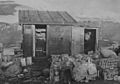
Teniente Esquivel Station, 1955.
-
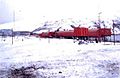
Corbeta Uruguay Base, 1981.


See also
 In Spanish: Isla Thule para niños
