Tule Island facts for kids

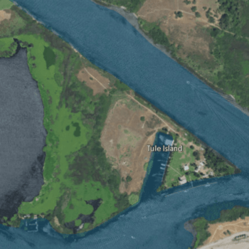
USGS aerial imagery of Tule Island, with Headreach Island to its northwest and McDonald Island to its southeast.
|
|
| Geography | |
|---|---|
| Location | Northern California |
| Coordinates | 38°01′41″N 121°28′39″W / 38.02806°N 121.47750°W |
| Adjacent bodies of water | Sacramento–San Joaquin River Delta |
| Highest elevation | 33 ft (10.1 m) |
| Administration | |
|
United States
|
|
| State | |
| County | San Joaquin |
Tule Island is a small island located in the Sacramento–San Joaquin River Delta in California. It is part of San Joaquin County. The island's exact location is 38°01′41″N 121°28′39″W / 38.02806°N 121.47750°W. In 1981, the United States Geological Survey measured its highest point to be about 33 feet (10 meters) above sea level.
Contents
Discover Tule Island
Tule Island is a fascinating spot within California's large delta region. Even though it's small, it plays a part in the unique environment of the Sacramento–San Joaquin River Delta. This area is a mix of rivers, channels, and islands.
Where is Tule Island Located?
Tule Island is found in the northern part of California. It sits within the Sacramento–San Joaquin River Delta, a huge area where two major rivers meet. This delta is a very important natural place.
- Part of San Joaquin County: Tule Island belongs to San Joaquin County. This county is in the central part of California.
- Coordinates: Its exact position is 38 degrees, 1 minute, 41 seconds North and 121 degrees, 28 minutes, 39 seconds West. These numbers help pinpoint its spot on a map.
What is the Sacramento–San Joaquin River Delta?
The Sacramento–San Joaquin River Delta is a special place where the Sacramento River and the San Joaquin River come together. Before flowing into San Francisco Bay, these rivers spread out into many smaller channels. This creates a network of waterways and islands.
- A Natural Wonder: The delta is one of the largest estuaries on the West Coast of the United States. An estuary is where fresh river water mixes with salty ocean water.
- Home to Wildlife: This area is home to many different kinds of plants and animals. Fish, birds, and other creatures live in and around the delta's waters.
- Important for Water: The delta is also a key source of water for many people in California. Water is pumped from here to farms and cities across the state.
How High is Tule Island?
Islands in a delta often have low elevations. Tule Island is no exception.
- Measured by USGS: The United States Geological Survey (USGS) is a science agency. They study the Earth's landscape and natural resources. In 1981, they measured Tule Island's elevation.
- Low Elevation: The island's highest point is about 33 feet (10 meters) above sea level. This means it's quite flat and close to the water's surface.

 | Bessie Coleman |
 | Spann Watson |
 | Jill E. Brown |
 | Sherman W. White |


