Headreach Island facts for kids

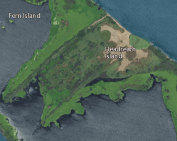
USGS aerial imagery of Headreach Island, with the Headreach Cutoff to its south, Fern Island to its northwest, and Tule Island to its southeast.
|
|
| Geography | |
|---|---|
| Location | Northern California |
| Coordinates | 38°01′55″N 121°29′04″W / 38.03194°N 121.48444°W |
| Adjacent bodies of water | Sacramento–San Joaquin River Delta |
| Highest elevation | 7 ft (2.1 m) |
| Administration | |
|
United States
|
|
| State | |
| County | San Joaquin |
Headreach Island is a small piece of land in the Sacramento–San Joaquin River Delta in Northern California. It is part of San Joaquin County. In 1981, the United States Geological Survey measured its highest point as about 7 feet (2.1 meters) above sea level.

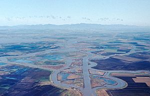
This aerial photo from 1965 shows Headreach Island (center, below Fern Island). You can also see Medford Island and Tinsley Island in the distance.
Where is Headreach Island?
Headreach Island is located in a special area called the Sacramento–San Joaquin River Delta. This delta is where the Sacramento and San Joaquin rivers meet before flowing into San Francisco Bay. It's a mix of islands, waterways, and wetlands.
The island's exact spot is at these coordinates: 38°01′55″N 121°29′04″W / 38.03194°N 121.48444°W. It's surrounded by water channels that connect to the larger delta system.
Black History Month on Kiddle
African-American Noble Laureates:
 | Toni Morrison |
 | Barack Obama |
 | Martin Luther King Jr. |
 | Ralph Bunche |

All content from Kiddle encyclopedia articles (including the article images and facts) can be freely used under Attribution-ShareAlike license, unless stated otherwise. Cite this article:
Headreach Island Facts for Kids. Kiddle Encyclopedia.


