Brookfield (CDP), Massachusetts facts for kids
Quick facts for kids
Brookfield, Massachusetts
|
|
|---|---|

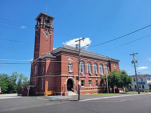
Town Hall
|
|
| Country | |
| State | Massachusetts |
| County | Worcester |
| Town | Brookfield |
| Area | |
| • Total | 1.15 sq mi (2.98 km2) |
| • Land | 1.15 sq mi (2.98 km2) |
| • Water | 0.00 sq mi (0.00 km2) |
| Elevation | 696 ft (212 m) |
| Population
(2020)
|
|
| • Total | 824 |
| • Density | 715.28/sq mi (276.09/km2) |
| Time zone | UTC-5 (Eastern (EST)) |
| • Summer (DST) | UTC-4 (EDT) |
| ZIP Code |
01506
|
| Area code(s) | 508/774 |
| FIPS code | 25-09070 |
| GNIS feature ID | 2630524 |
Brookfield is a special kind of place in Massachusetts, United States. It's called a census-designated place (CDP). This means it's an area that the government counts as a separate community for population surveys. Brookfield is part of the larger town of Brookfield in Worcester County.
Major roads like Massachusetts Route 9 and Massachusetts Route 148 go through the center of Brookfield. Route 9 connects Brookfield to towns like Spencer to the east and Ware to the west. Route 148 crosses Route 9 and leads to North Brookfield in the north and Fiskdale in the south. Brookfield was first recognized as a CDP after the 2010 United States census.
Contents
People in Brookfield
How Many People Live Here?
Brookfield has a population of 824 people. This number comes from the 2020 census. A census is like a big count of everyone living in a country. It helps us understand how communities are growing and changing.
| Historical population | |||
|---|---|---|---|
| Census | Pop. | %± | |
| 2020 | 824 | — | |
| U.S. Decennial Census | |||
More About Brookfield
Where Can You Learn More?
- In Spanish: Brookfield (condado de Worcester) para niños


