Ware (CDP), Massachusetts facts for kids
Quick facts for kids
Ware, Massachusetts
|
|
|---|---|

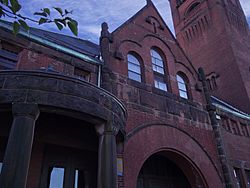
Ware Town Hall
|
|

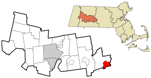
Location in Hampshire County in Massachusetts
|
|
| Country | United States |
| State | Massachusetts |
| County | Hampshire |
| Town | Ware |
| Area | |
| • Total | 6.36 sq mi (16.46 km2) |
| • Land | 6.22 sq mi (16.11 km2) |
| • Water | 0.14 sq mi (0.35 km2) |
| Elevation | 423 ft (129 m) |
| Population
(2020)
|
|
| • Total | 6,266 |
| • Density | 1,007.40/sq mi (388.95/km2) |
| Time zone | UTC-5 (Eastern (EST)) |
| • Summer (DST) | UTC-4 (EDT) |
| ZIP code |
01082
|
| Area code(s) | 413 |
| FIPS code | 25-72845 |
| GNIS feature ID | 0609762 |
Ware is a special kind of community called a census-designated place (CDP). It's the main village within the larger town of Ware in Hampshire County, Massachusetts, United States. In 2010, about 6,170 people lived in the CDP. The entire town of Ware had a population of 9,872 people. Ware is also part of the larger Springfield area.
Contents
Exploring Ware's Location
The Ware CDP is found in the southeastern part of the town of Ware. Its exact location is 42°15′35″N 72°14′45″W / 42.25972°N 72.24583°W.
Neighboring Towns
Ware is surrounded by several other towns. To the east, you'll find West Brookfield. To the southeast is Warren, and to the south is Palmer. The rest of the town of Ware is to the west and north.
Land and Water Features
Ware covers an area of about 16.4 square kilometers (6.3 square miles). Most of this area is land, with a small part, about 0.4 square kilometers (0.14 square miles), being water.
The Ware River flows right through the middle of the village. It travels southwest and joins the Quaboag River in Palmer. When these two rivers meet, they form the Chicopee River.
Major Roads in Ware
Two main roads pass through Ware:
- Massachusetts Route 9 runs through the center of Ware. It's known as Main Street. This road goes east about 27 miles to Worcester. It also goes northwest about 19 miles to Amherst.
- Massachusetts Route 32 also joins Route 9 in the center of Ware. This route follows the Ware River valley. It leads northeast about 15 miles to Barre. It also goes southwest about 9 miles to Palmer.
Who Lives in Ware?
| Historical population | |||
|---|---|---|---|
| Census | Pop. | %± | |
| 2020 | 6,266 | — | |
| U.S. Decennial Census | |||
In 2000, there were 6,174 people living in the Ware CDP. These people lived in 2,685 households. About 1,592 of these households were families.
Population Details
The population density was about 386 people per square kilometer (999 people per square mile). There were also 2,906 housing units available.
Most people in Ware were White (about 95.59%). Other groups included African American, Native American, and Asian people. About 2.74% of the population identified as Hispanic or Latino.
Households and Families
Out of all the households, about 28% had children under 18 living with them. About 38.5% were married couples living together. Some households (14.9%) had a female head with no husband present. About 40.7% were not families.
Many households (34.1%) were made up of just one person. About 15.4% of households had someone aged 65 or older living alone. On average, there were 2.30 people in each household and 2.92 people in each family.
Age Groups
The population in Ware was spread across different age groups:
- About 24.9% were under 18 years old.
- About 9.2% were between 18 and 24 years old.
- About 28.5% were between 25 and 44 years old.
- About 20.1% were between 45 and 64 years old.
- About 17.3% were 65 years old or older.
The average age of people in Ware was 36 years. For every 100 females, there were about 91.7 males.
See also
 In Spanish: Ware (condado de Hampshire) para niños
 | Selma Burke |
 | Pauline Powell Burns |
 | Frederick J. Brown |
 | Robert Blackburn |

