Brookwood, Alabama facts for kids
Quick facts for kids
Brookwood, Alabama
|
||
|---|---|---|
| City of Brookwood | ||
|
||

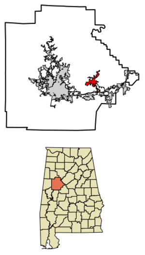
Location of Brookwood in Tuscaloosa County, Alabama.
|
||
| Country | United States | |
| State | Alabama | |
| County | Tuscaloosa | |
| Government | ||
| • Type | Mayor-Council | |
| Area | ||
| • Total | 8.46 sq mi (21.91 km2) | |
| • Land | 8.37 sq mi (21.68 km2) | |
| • Water | 0.09 sq mi (0.23 km2) | |
| Elevation | 600 ft (200 m) | |
| Population
(2020)
|
||
| • Total | 2,504 | |
| • Density | 299.13/sq mi (115.50/km2) | |
| Time zone | UTC-6 (Central (CST)) | |
| • Summer (DST) | UTC-5 (CDT) | |
| ZIP code |
35444
|
|
| Area code(s) | 205, 659 | |
| FIPS code | 01-09808 | |
| GNIS feature ID | 0114971 | |
Brookwood is a city located in Tuscaloosa County, Alabama, in the United States. It became an official city in September 1977. According to the 2020 census, about 2,504 people live there.
Contents
History of Brookwood
The 2001 Mine Event
On September 23, 2001, two explosions happened at the Jim Walter Resources Blue Creek No. 5 mine. This occurred around 5:20 p.m. and 6:15 p.m. Sadly, thirteen miners lost their lives. At the time, thirty-two miners were working underground. Ten of those who were killed chose to stay behind. They were trying to help rescue others who were trapped after the first explosion.
People of Brookwood (Demographics)
| Historical population | |||
|---|---|---|---|
| Census | Pop. | %± | |
| 1970 | 196 | — | |
| 1980 | 492 | 151.0% | |
| 1990 | 658 | 33.7% | |
| 2000 | 1,483 | 125.4% | |
| 2010 | 1,828 | 23.3% | |
| 2020 | 2,504 | 37.0% | |
| U.S. Decennial Census 2013 Estimate |
|||
Brookwood has grown quite a bit over the years. In 1970, only 196 people lived there. By 2020, the population had grown to 2,504.
Brookwood in 2000
During the 2000 census, there were 1,483 people living in Brookwood. They lived in 553 households, with 430 of these being families. Most people (97.91%) were White. A small number were Black or African American (0.54%), Native American (0.07%), or Asian (0.13%). Some people were from other races or had mixed backgrounds. About 0.34% of the population was Hispanic or Latino.
Many households (42.1%) had children under 18 living with them. The average household had about 2.68 people. The average family had about 3.07 people. The median age in Brookwood was 34 years old. This means half the people were younger than 34 and half were older.
Brookwood in 2010
By the 2010 census, the population had grown to 1,828 people. There were 659 households, and 516 of these were families. The racial makeup changed slightly. About 92.2% of the people were White, and 5.3% were Black or African American. Other groups included Native American (0.7%) and Asian (0.1%). About 2.0% of the population was Hispanic or Latino.
Around 38.1% of households had children under 18. The average household size was 2.77 people, and the average family size was 3.11 people. The median age in 2010 was 32 years.
Education in Brookwood
Brookwood is part of the Tuscaloosa County School System. The city has one elementary school, one middle school, and one high school.
City Services (Infrastructure)
Getting Around (Transportation)
Brookwood has two main roads that help people travel. These are Alabama State Route 216, which goes northeast to west, and County Road 59, which runs north to south.
Weather in Brookwood (Climate)
The weather in Brookwood is usually warm and humid in the summer. Winters are generally mild to cool. This type of weather is called a humid subtropical climate. On climate maps, it's shown as "Cfa."
| Climate data for Brookwood, Alabama | |||||||||||||
|---|---|---|---|---|---|---|---|---|---|---|---|---|---|
| Month | Jan | Feb | Mar | Apr | May | Jun | Jul | Aug | Sep | Oct | Nov | Dec | Year |
| Mean daily maximum °C (°F) | 11 (52) |
14 (57) |
19 (66) |
24 (75) |
28 (82) |
32 (89) |
33 (91) |
33 (91) |
30 (86) |
24 (76) |
19 (66) |
13 (56) |
23 (74) |
| Mean daily minimum °C (°F) | −1 (30) |
1 (33) |
4 (40) |
9 (48) |
13 (56) |
18 (64) |
20 (68) |
19 (67) |
17 (62) |
9 (49) |
5 (41) |
1 (34) |
9 (49) |
| Average precipitation mm (inches) | 140 (5.7) |
130 (5.2) |
150 (6) |
120 (4.7) |
110 (4.4) |
120 (4.7) |
140 (5.5) |
99 (3.9) |
100 (4) |
81 (3.2) |
120 (4.7) |
120 (4.9) |
1,440 (56.8) |
| Source: Weatherbase | |||||||||||||
See also
 In Spanish: Brookwood (Alabama) para niños
 | Isaac Myers |
 | D. Hamilton Jackson |
 | A. Philip Randolph |


