Browns, Illinois facts for kids
Quick facts for kids
Browns, Illinois
|
|
|---|---|

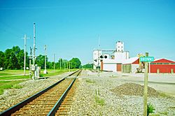
Railroad tracks in Browns
|
|

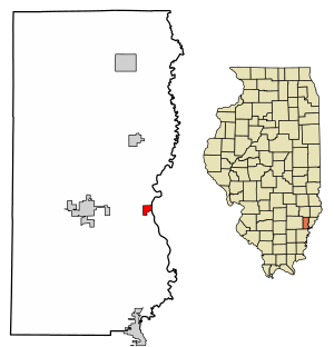
Location of Browns in Edwards County, Illinois.
|
|

Location of Illinois in the United States
|
|
| Country | United States |
| State | Illinois |
| County | Edwards |
| Area | |
| • Total | 0.29 sq mi (0.75 km2) |
| • Land | 0.29 sq mi (0.75 km2) |
| • Water | 0.00 sq mi (0.00 km2) |
| Elevation | 397 ft (121 m) |
| Population
(2020)
|
|
| • Total | 139 |
| • Density | 479.31/sq mi (185.25/km2) |
| Time zone | UTC-6 (CST) |
| • Summer (DST) | UTC-5 (CDT) |
| Area code(s) | 618 |
| FIPS code | 17-08979 |
| GNIS ID | 2397472 |
| Wikimedia Commons | Browns, Illinois |
Browns is a small village in Edwards County, Illinois, in the United States. In 2020, about 139 people lived there. This was a small increase from 134 people in 2010.
Contents
History of Browns Village
Sadly, many early records about Browns were lost in a fire. The known history of Browns starts in 1880. A couple named John and Emma Henderson planned the town. They created its streets and lots. They first called the area "Frazier".
On May 7, 1892, people asked for a vote to make it an official village. The vote happened on May 24, 1892. It was a close vote, with 31 people voting yes and 27 voting no. The village was named "Browns" to honor John L. Brown, who was an important person in the community.
Where is Browns Located?
Browns is located on the eastern side of Edwards County. The eastern edge of the village is next to Bonpas Creek. This creek also marks the border with Wabash County.
Illinois Route 15 passes just north of Browns. This road goes west about 4 miles (6.4 km) to Albion. Albion is the main town in Edwards County. The road also goes east about 13 miles (21 km) to Mount Carmel.
According to the 2010 census, Browns covers a total area of 0.29 square miles (0.75 square kilometers). All of this area is land.
People Living in Browns
| Historical population | |||
|---|---|---|---|
| Census | Pop. | %± | |
| 1900 | 421 | — | |
| 1910 | 419 | −0.5% | |
| 1920 | 388 | −7.4% | |
| 1930 | 302 | −22.2% | |
| 1940 | 337 | 11.6% | |
| 1950 | 336 | −0.3% | |
| 1960 | 251 | −25.3% | |
| 1970 | 198 | −21.1% | |
| 1980 | 213 | 7.6% | |
| 1990 | 207 | −2.8% | |
| 2000 | 175 | −15.5% | |
| 2010 | 134 | −23.4% | |
| 2020 | 139 | 3.7% | |
| U.S. Decennial Census | |||
In 2020, there were 139 people living in Browns. These people lived in 91 households. About 57 of these households were families. The village had about 479 people per square mile (185 people per square kilometer). There were 67 homes in total.
Most people in Browns (99.28%) were White. A very small number (0.72%) were African American. Also, 0.72% of the population identified as Hispanic or Latino.
About 28.6% of households had children under 18 living with them. More than half (54.95%) were married couples. About 21.98% of households had only one person living there. About 12.09% of households had someone aged 65 or older living alone.
The average age of people in Browns was 46.0 years old. About 26.1% of the population was under 18. About 12.8% were 65 years or older.
The average income for a household in Browns was $63,125 per year. For families, the average income was $76,750 per year. The average income per person in the village was $26,477. About 16.4% of all people in Browns lived below the poverty line. This included 8.5% of those under 18 and 6.9% of those 65 or older.
Famous People from Browns
- Franklin P. Buyer was a member of the Los Angeles City Council from 1933 to 1939. He went to school in Browns.
See also
 In Spanish: Browns para niños
 | Selma Burke |
 | Pauline Powell Burns |
 | Frederick J. Brown |
 | Robert Blackburn |


