Browns Island (Contra Costa County) facts for kids

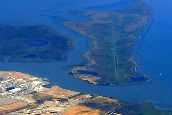
An aerial photo of Browns Island (on the left). Winter Island is on the right of the image, and Antioch is on the bottom.
|
|
| Geography | |
|---|---|
| Location | Suisun Bay |
| Coordinates | 38°02′20″N 121°51′53″W / 38.03881°N 121.86468°W |
| Area | 595 acres (241 ha) |
| Highest elevation | 0 m (0 ft) |
| Administration | |
|
United States
|
|
| U.S. state | California |
| County | Contra Costa County |
| City | Pittsburg |
| Demographics | |
| Population | 0 |
Browns Island is a special place in Pittsburg, Contra Costa County, California. It's also known as Gwin Island or Brown Island. This island is a protected area called a regional preserve, managed by the East Bay Regional Park District (EBRPD).
Browns Island is located in Suisun Bay, which is part of the huge Sacramento-San Joaquin River Delta. It's separated from the city of Pittsburg by a narrow waterway called New York Slough.
Island Geography
Browns Island is about 595 acres big, which is like 450 football fields! It's surrounded by water on all sides. To the east, it's separated from Winter Island by another waterway called Middle Slough. On its south side, you'll find New York Slough, and to the west and northwest is Suisun Bay.
A Look Back in Time
Maps from long ago show Browns Island with a different name. On an 1850 map of the San Francisco Bay area, made by Cadwalader Ringgold, the island was labeled "Gwin Island." An 1854 map by Henry Lange also used this name. It's interesting how places can have different names over time!
Nature and Wildlife
Browns Island is a very important home for nature. The East Bay Regional Park District has even created a guide to all the amazing wild plants that grow there.
This island is especially important because it's home to six types of plants that are very rare or endangered. This means they are special and need protection so they don't disappear. You can also find many different kinds of aquatic birds living on the island. These birds love the watery environment of the delta.


