Bruce Tunnel facts for kids
 |
|
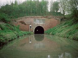
| Bruce Tunnel - Eastern Portal (as seen in 1992) | |
| Overview | |
|---|---|
| Location | Wiltshire, England |
| Coordinates | 51°22′04″N 1°39′46″W / 51.3677°N 1.6627°W |
| OS grid reference | SU23586323 |
| Status | Open |
| Waterway | Kennet and Avon Canal |
| Operation | |
| Owner | Canal & River Trust |
| Technical | |
| Construction | 1806-1809 |
| Length | 502 yards (459 m) |
| Towpath | No |
The Bruce Tunnel is a cool old tunnel on the Kennet and Avon Canal in Wiltshire, England. This canal connects the cities of London and Bristol by water. The tunnel is found on the highest part of the canal, called the "summit pound." It sits between two sets of locks: Wootton Top Lock and Crofton Locks.
The tunnel is about 502 yards (459 m) long. That's more than five football fields! It's named after a powerful local landowner, Thomas Brudenell-Bruce, 1st Earl of Ailesbury. When the canal was being built, he didn't want a deep ditch (called a cutting) dug through his land. So, he insisted they build a tunnel instead.
Contents
Why the Bruce Tunnel Was Built
The Bruce Tunnel was built because a very important person, Thomas Bruce, the Earl of Ailesbury, wanted it that way. He owned the land where the canal needed to go. Instead of letting the canal company dig a deep trench through his property, he said they had to build a tunnel. This shows how much influence landowners had back then!
Building the Tunnel
Work on the tunnel started in 1806 and was finished in 1809. The entrances to the tunnel, called portals, are made of red brick. They have fancy tops made of Bath stone, which is a type of limestone. Each entrance also has a special stone plaque with decorations. Inside, the tunnel is lined with strong brickwork. It was built wide enough to fit the large 'Newbury Barges' that used the canal.
A Special Plaque
At the eastern end of the tunnel, there's a special plaque. It was put there to thank the Earl of Ailesbury and his son, Charles Lord Bruce. The plaque says that the Kennet and Avon Canal Company named the tunnel "BRUCE" to show their thanks. It mentions their "uniform and effectual Support" for the canal. This support helped open a direct water route between London and Bristol in 1810.
How Boats Traveled Through Bruce Tunnel
Today, boats often have engines, but back when the Bruce Tunnel was built, boats were pulled by horses. However, there is no towpath (a path for horses) inside the tunnel. So, what did the boatmen do?
- Legging it: The boatmen had to pull the boats through the tunnel by hand! They would lie on their backs on the boat and "walk" their feet along the tunnel walls or pull on chains fixed inside the tunnel. This was very hard work!
- Walkers and Cyclists: If you're walking or cycling along the canal today, you can't go through the tunnel. Instead, you have to go over the top of the hill.
Location and Nearby Attractions
The Bruce Tunnel is about 1.3 miles (2 km) north of a village called Burbage.
- Savernake Forest: To the north of the tunnel is the beautiful Savernake Forest. This forest is open to everyone and has lots of footpaths, drives, and picnic spots. Because it's so close to this forest, the tunnel is sometimes also called the Savernake Tunnel.
- Railway Line: A major railway line, the 'Berks and Hants' line, crosses over the tunnel. If you're on a train passing by, you can sometimes see the tunnel entrances from the train windows! The canal runs very close to the railway at both ends of the tunnel.
See also
 In Spanish: Túnel de Bruce para niños
 | John T. Biggers |
 | Thomas Blackshear |
 | Mark Bradford |
 | Beverly Buchanan |

