
Bruck an der Leitha District facts for kids
Quick facts for kids
Bruck an der Leitha District
Bezirk Bruck an der Leitha
|
|
|---|---|
 |
|
| Country | Austria |
| State | Lower Austria |
| Number of municipalities | 33 |
| Area | |
| • Total | 703.0 km2 (271.4 sq mi) |
| Population
(1 January 2016)
|
|
| • Total | 98,244 |
| • Density | 139.750/km2 (361.950/sq mi) |
| Time zone | UTC+01:00 (CET) |
| • Summer (DST) | UTC+02:00 (CEST) |
| NUTS code | AT122 |
The Bruck an der Leitha District is a special area in Lower Austria, which is one of the nine states in Austria. It's like a county or region within a state.
This district covers about 703 square kilometers. That's roughly the size of 100,000 football fields! As of January 1, 2019, around 102,010 people lived here. The main town and administrative center of the district is Bruck an der Leitha.
Towns and Villages
This district is made up of many different towns and villages. Some are larger towns, while others are smaller market towns or tiny hamlets.
Here are the main places in the Bruck an der Leitha District:
- Au am Leithaberge
- Bad Deutsch-Altenburg
- Berg
- Bruck an der Leitha
- This includes Bruck an der Leitha, Wilfleinsdorf, and Schloss Prugg.
- Ebergassing
- This includes Ebergassing and Wienerherberg.
- Enzersdorf an der Fischa
- This includes Enzersdorf an der Fischa and Margarethen am Moos.
- Fischamend
- This includes Fischamend-Dorf and Fischamend-Markt.
- Göttlesbrunn-Arbesthal
- This includes Arbesthal and Göttlesbrunn.
- Götzendorf an der Leitha
- This includes Götzendorf an der Leitha and Pischelsdorf.
- Gramatneusiedl
- Hainburg an der Donau
- Haslau-Maria Ellend
- This includes Haslau an der Donau and Maria Ellend.
- Himberg
- This includes Himberg, Velm, Pellendorf, and Gutenhof.
- Hof am Leithaberge
- Höflein
- Hundsheim
- Klein-Neusiedl
- Lanzendorf
- Leopoldsdorf
- Mannersdorf am Leithagebirge
- This includes Mannersdorf am Leithagebirge and Wasenbruck.
- Maria Lanzendorf
- Moosbrunn
- Petronell-Carnuntum
- Prellenkirchen
- This includes Deutsch-Haslau, Prellenkirchen, and Schönabrunn.
- Rauchenwarth
- Rohrau
- This includes Gerhaus, Hollern, Pachfurth, and Rohrau.
- Scharndorf
- This includes Regelsbrunn, Scharndorf, and Wildungsmauer.
- Schwadorf
- Schwechat
- This includes Kledering, Mannswörth, Rannersdorf, and Schwechat.
- Sommerein
- Trautmannsdorf an der Leitha
- This includes Gallbrunn, Sarasdorf, Stixneusiedl, and Trautmannsdorf an der Leitha.
- Wolfsthal
- Zwölfaxing
Recent Changes
In 2017, the Bruck an der Leitha District became larger. It took in several towns and villages from another district called Wien-Umgebung District, which was closed down. These new places included Ebergassing, Fischamend, Gramatneusiedl, Himberg, Klein-Neusiedl, Lanzendorf, Leopoldsdorf, Maria Lanzendorf, Moosbrunn, Rauchenwarth, Schwadorf, Schwechat, and Zwölfaxing. This change made the Bruck an der Leitha District bigger and more important.
Images for kids
-
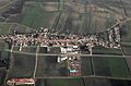
Gallbrunn, Austria
-
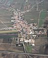
Göttlesbrunn, Austria


See also
 In Spanish: Distrito de Bruck an der Leitha para niños
