Brunswick River (Georgia) facts for kids
Quick facts for kids Brunswick River |
|
|---|---|

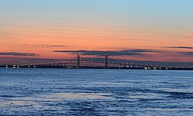
The Sidney Lanier Bridge over the Brunswick River
|
|
| Country | United States |
| Physical characteristics | |
| Main source | Glynn County, Georgia |
| River mouth | 0 m 31°07′13″N 81°25′35″W / 31.12023°N 81.42649°W |
The Brunswick River is a special kind of waterway in Glynn County, Georgia. It's a tidal river, which means its water levels go up and down with the ocean's tides. This river is about 6 miles (10 kilometers) long.
About the Brunswick River
The Brunswick River starts where two other rivers meet. These are the South Brunswick River and the Turtle River. This meeting point is located southeast of a city called Brunswick. From there, the Brunswick River flows east.
Where Does It Flow?
The river's journey ends at a place called St. Simons Sound. This sound is like a narrow channel of water. It sits between two islands: Saint Simons Island to the north and Jekyll Island to the south. The river's connection to the ocean makes it important for boats and ships.
Bridges and Crossings
Several important structures cross the rivers and sounds in this area.
- The famous Sidney Lanier Bridge goes over the Brunswick River. It's a very tall bridge!
- I-95 and Georgia State Route 303 cross the Turtle River. These are busy roads that help people travel.
- The Torres Causeway helps people get across St. Simons Sound.
- The Jekyll Island Causeway connects the mainland to Jekyll Island by crossing Jekyll Sound.
 | Roy Wilkins |
 | John Lewis |
 | Linda Carol Brown |

