Brushton, New York facts for kids
Quick facts for kids
Brushton, New York
|
|
|---|---|
|
Village
|
|

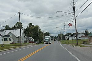
Downtown Brushton on US11
|
|
| Country | United States |
| State | New York |
| County | Franklin |
| Town | Moira |
| Named for | Henry N. Brush |
| Area | |
| • Total | 0.28 sq mi (0.72 km2) |
| • Land | 0.28 sq mi (0.72 km2) |
| • Water | 0.00 sq mi (0.00 km2) |
| Elevation | 420 ft (128 m) |
| Population
(2020)
|
|
| • Total | 443 |
| • Density | 1,605.07/sq mi (618.84/km2) |
| Time zone | UTC-5 (Eastern (EST)) |
| • Summer (DST) | UTC-4 (EDT) |
| ZIP code |
12916
|
| Area code(s) | 518 |
| FIPS code | 36-10286 |
| GNIS feature ID | 0944982 |
Brushton is a small village in Franklin County, New York, United States. In 2020, about 443 people lived there. The village got its name from Henry Brush, who owned a lot of land in the area.
Brushton is located within the larger town of Moira. It is west of Malone, which is the main town for the county.
History of Brushton
The village was first known as Brush's Mills. This name came from the mills built on the Little Salmon River. Mr. Henry N. Brush bought these mills in 1835.
On October 1, 1877, the small settlement was officially named "Brushton."
Long ago, in 1918, a book called Historical Sketches of Franklin County, NY talked about Brushton. It said that the area was mostly for farming. There were two small villages, Brushton and Moira. Both had train stations on the Rutland Railroad. They were also on important main roads.
One of the first settlers, Appleton Foote, built a saw mill in Brushton. A saw mill cuts wood into planks. The next year, he built a grist mill. A grist mill grinds grain into flour. This first grist mill was replaced in 1823 by a stone mill. Henry N. Brush later improved this mill.
Henry N. Brush moved to Brush's Mills in 1835. He was a very smart and educated man. He was also a good public speaker. He owned a lot of land. He helped the eastern part of Moira grow with new businesses. Henry N. Brush passed away in 1872.
Henry N. Brush's son, Henry Corbin Brush, was born in Brush's Mills in 1838. He was an inventor. He created the Brush Trolling Spoon. This was a special fishing lure that could run shallow in the water.
Geography of Brushton
Brushton is in the eastern part of the town of Moira. It is in the northwestern part of Franklin County.
The United States Census Bureau says the village covers about 0.72 square kilometers (0.28 square miles). All of this area is land.
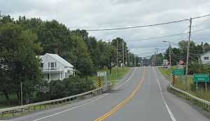
Brushton is located right on U.S. Route 11. This road is also called Washington Street. It meets County Road 8 there. County Road 8 is known as Fay-Brushton Road or Farm-To-Market Road.
If you travel west on US-11, the community of Moira is about 2 miles away. North Bangor is about 5.5 miles to the east. The larger town of Malone is about 11 miles east on US-11.
The Little Salmon River flows through the village. It flows north. The water from this river eventually reaches the St. Lawrence River. This big river is located just across the border in Quebec, Canada.
Population of Brushton
The population of Brushton has changed over the years.
| Historical population | |||
|---|---|---|---|
| Census | Pop. | %± | |
| 1880 | 328 | — | |
| 1890 | 598 | 82.3% | |
| 1930 | 470 | — | |
| 1940 | 487 | 3.6% | |
| 1950 | 516 | 6.0% | |
| 1960 | 553 | 7.2% | |
| 1970 | 547 | −1.1% | |
| 1980 | 577 | 5.5% | |
| 1990 | 522 | −9.5% | |
| 2000 | 479 | −8.2% | |
| 2010 | 474 | −1.0% | |
| 2020 | 443 | −6.5% | |
| U.S. Decennial Census | |||
In 2000, there were 479 people living in Brushton. There were 213 households, which means groups of people living together. About 119 of these were families.
Many homes had children under 18 living there. Some households were married couples. Others were single parents or individuals living alone. About 18.8% of homes had someone 65 years or older living by themselves.
The average age of people in the village in 2000 was 40 years old. About 24.6% of the population was under 18. About 18.0% of the population was 65 years or older.
See also
 In Spanish: Brushton para niños
 | Misty Copeland |
 | Raven Wilkinson |
 | Debra Austin |
 | Aesha Ash |


