Buchanan Point facts for kids
Quick facts for kids Buchanan Point |
|
|---|---|
| Coordinates | 60°43′S 44°28′W / 60.717°S 44.467°W |
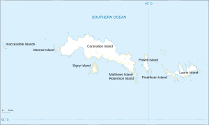
Buchanan Point is a piece of land that sticks out into the sea, located in Antarctica. It's found on the north-eastern part of Laurie Island, which is one of the South Orkney Islands. This point is about 5 kilometers (3 miles) north-west of Cape Dundas and 2 kilometers (1.2 miles) south-east of Mackintosh Cove.
Why is it Called Buchanan Point?
The name of a place often has an interesting story, and "Buchanan Point" is no different! This is called its etymology.
Back in 1903, a group of explorers from Scotland, led by William Speirs Bruce, were on an adventure called the Scottish National Antarctic Expedition. They decided to name a nearby cape "Cape Buchanan." They did this to honor J.Y. Buchanan, who was part of another famous sea journey called the Challenger Expedition (1872–76).
However, there was already another cape in the area that a French expedition had named "Cape Valavielle" way back in 1838. For a while, the names got a bit mixed up. To make sure everyone knew which place was which, the UK Antarctic Place-Names Committee stepped in during 1954. They decided that the name Cape Valavielle should stay with the original prominent cape. To keep the history of the name "Buchanan" alive, they officially named the point we are talking about now "Buchanan Point."
A Special Place for Birds
Buchanan Point is very important for wildlife, especially birds! It has been recognized as an Important Bird Area (IBA) by an organization called BirdLife International.
This means it's a crucial spot for birds to live and raise their young. Why is it so special? Because Buchanan Point is home to a huge bird colony of chinstrap penguins. Imagine seeing about 10,000 pairs of these amazing penguins living and breeding there! It's a bustling and lively place for these Antarctic residents.
 | DeHart Hubbard |
 | Wilma Rudolph |
 | Jesse Owens |
 | Jackie Joyner-Kersee |
 | Major Taylor |


