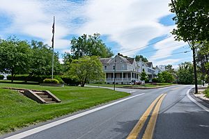
Buckeystown, Maryland facts for kids
Quick facts for kids
Buckeystown, Maryland
|
|
|---|---|

Buckeystown
|
|
| Country | |
| State | |
| County | |
| Area | |
| • Total | 0.91 sq mi (2.37 km2) |
| • Land | 0.91 sq mi (2.36 km2) |
| • Water | 0.00 sq mi (0.00 km2) |
| Elevation | 269 ft (82 m) |
| Population
(2020)
|
|
| • Total | 1,072 |
| • Density | 1,174.15/sq mi (453.29/km2) |
| Time zone | UTC−5 (Eastern (EST)) |
| • Summer (DST) | UTC−4 (EDT) |
| ZIP code |
21717
|
| Area code(s) | 301, 240 |
| FIPS code | 24-11050 |
| GNIS feature ID | 2583592 |
Buckeystown is a small community in Frederick County, Maryland, United States. It's known as a census-designated place (CDP), which means it's an area that the government counts for population statistics, but it doesn't have its own local government like a city or town.
In 2020, about 1,072 people lived in Buckeystown. The area is home to several important historical sites. These include the Buckeystown Historic District and the Buckingham House and Industrial School Complex. Both were added to the National Register of Historic Places in 1982. This list includes places that are important to the history of the United States. Carrollton Manor, another historic site, was added to the list in 1997. A former member of Congress, Roscoe Bartlett, lives on a farm in Buckeystown.
Contents
A Look Back in Time
How Buckeystown Started
The story of Buckeystown began in 1731. A man named Meridith Davis received a special paper called a "patent" for a piece of land. He named this land "Good Luck." This land was perfect for new settlers because it was flat, fertile, and close to the Monocacy River. Many European immigrants and settlers moved here, especially from the Colony of New Jersey.
Early Settlers and Quakers
Among the first people to settle here were Henry Ballenger and Josiah Ballenger Sr. They were Quakers, a religious group known for their peaceful beliefs. The Ballenger and Davis families, who were also Quakers, started a Quaker meeting group in the area. In 1739, Meridith Davis gave some of his "Good Luck" land to build a meetinghouse. Even though many Quakers later moved to Virginia, this group was one of the first religious organizations in what is now Frederick County.
Growth of the Village
During the American Revolutionary War, two brothers, John and George Buckey, settled on the old "Good Luck" land. They started businesses and factories, which helped the village grow. This is how Buckeystown got its name!
In the 1800s, the Baker family played a big role in the town's growth. They bought the Buckey family's tannery (a place where animal hides are made into leather) in 1832. The Baker family also started the town's cannery (a factory for canning food), helped build the Methodist Church, and founded an industrial school for boys. Their efforts helped Buckeystown become a busy and important community.
Where is Buckeystown?
Buckeystown is located in the southern part of Frederick County. It sits along Maryland Route 85. This road goes north about 6 miles to Frederick, which is the main city and "county seat" of Frederick County. It also goes south about 5.5 miles towards the Potomac River.
The community also stretches east to the Monocacy River. Another road, Maryland Route 80, goes east from Buckeystown about 5.5 miles to Urbana.
Size of the Area
Buckeystown covers a total area of about 4.0 square kilometers (or 0.91 square miles). Only a very small part of this area, about 0.02 square kilometers, is water.
People in Buckeystown
The population of Buckeystown has changed over the years. Here's a quick look at how many people have lived there:
| Historical population | |||
|---|---|---|---|
| Census | Pop. | %± | |
| 2020 | 1,072 | — | |
| U.S. Decennial Census | |||
Places of Worship
Buckeystown has several churches for its residents. These include two United Methodist churches, a Roman Catholic church called St. Joseph's, and an Anglican church named St. Michael the Archangel Anglican Catholic Church.
See also
 In Spanish: Buckeystown (Maryland) para niños


