Buckhorn, Pennsylvania facts for kids
Quick facts for kids
Buckhorn, Pennsylvania
|
|
|---|---|

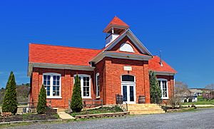
One-room schoolhouse
|
|

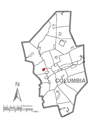
Location within Columbia County
|
|
| Country | United States |
| State | Pennsylvania |
| County | Columbia |
| Township | Hemlock |
| Area | |
| • Total | 0.68 sq mi (1.75 km2) |
| • Land | 0.67 sq mi (1.74 km2) |
| • Water | 0.01 sq mi (0.01 km2) |
| Elevation | 602 ft (183 m) |
| Population
(2020)
|
|
| • Total | 332 |
| • Density | 494.05/sq mi (190.61/km2) |
| Time zone | UTC-5 (Eastern (EST)) |
| • Summer (DST) | UTC-4 (EDT) |
| ZIP code |
17815
|
| Area code(s) | 570 |
| FIPS code | 42-09792 |
| GNIS feature ID | 1192212 |
Buckhorn is a small community in Columbia County, Pennsylvania, United States. It is known as a census-designated place (CDP). This means it is a special area defined by the U.S. Census Bureau for collecting population data. Buckhorn is part of Northeastern Pennsylvania and is also included in the Bloomsburg-Berwick micropolitan area. In 2020, about 332 people lived there. The ZIP code for Buckhorn is 17815, which is shared with Bloomsburg.
History of Buckhorn
Long ago, a path used by Native Americans went through the Buckhorn area. A deer with large antlers once marked this path on a young white oak tree. When the first non-native settlers arrived, they made another path. This new path crossed the old Native American path. The community was named "Buckhorn" because of the deer antlers that marked the original trail.
Buckhorn started as a community because people found ore (a type of rock with valuable minerals) in the area. The very first house in Buckhorn was built in 1820 by Vaniah Rees. Later, in 1836, the first store opened, making it easier for people to buy what they needed. Mail delivery began in 1850, but it wasn't until 1883 that mail was delivered to Buckhorn every day.
Buckhorn's Location and Land
Buckhorn is located in the western part of Columbia County. You can find it at these coordinates: 41°0′56″N 76°29′54″W / 41.01556°N 76.49833°W. It is in the eastern section of Hemlock Township.
The United States Census Bureau says that Buckhorn covers a total area of about 1.75 square kilometers (0.68 square miles). Most of this area is land, with only a tiny bit (0.01 square kilometers or 0.01 square miles) being water. The water in Buckhorn drains into Fishing Creek, which then flows into the Susquehanna River.
Several important roads pass through or near Buckhorn. These include Pennsylvania Route 42, Pennsylvania Route 44, and Interstate 80. The land in Buckhorn is mostly flat, but there are some small hills in the southern and northeastern parts. Outside the main center of town, you can see farmland and even a golf course. The Columbia Colonnade (which used to be called Columbia Mall) is located just east of Buckhorn, right by PA Route 42 and its connection to Interstate 80.
People of Buckhorn
| Historical population | |||
|---|---|---|---|
| Census | Pop. | %± | |
| 2020 | 332 | — | |
| U.S. Decennial Census | |||
According to the census taken in 2000, there were 176 people living in Buckhorn. These people made up 63 households, and 45 of those were families. The population density was about 288.8 people per square mile. There were 63 homes, with an average of 103.4 homes per square mile.
In terms of background, all residents counted in the 2000 census were White.
Looking at the age groups in 2000:
- About 27.8% of the people were under 18 years old.
- About 6.8% were between 18 and 24 years old.
- About 26.7% were between 25 and 44 years old.
- About 23.3% were between 45 and 64 years old.
- About 15.3% were 65 years old or older.
The average age of people in Buckhorn in 2000 was 36 years. For every 100 females, there were about 89.2 males.
See also
 In Spanish: Buckhorn (Pensilvania) para niños
 | Shirley Ann Jackson |
 | Garett Morgan |
 | J. Ernest Wilkins Jr. |
 | Elijah McCoy |


