Bude Canal facts for kids
Quick facts for kids Bude Canal |
|
|---|---|
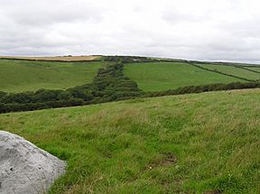
The course of Hobbacott Incline in 2007; it ascends the hillside, marked by the twin rows of trees
|
|
| Specifications | |
| Maximum boat length | 20 ft 0 in (6.096 m) |
| Maximum boat beam | 5 ft 6 in (1.68 m) |
| Locks | 2 + 6 inclines |
| Status | part extant |
| History | |
| Principal engineer | James Green (1781-1849), Thomas Shearm |
| Date of act | 1819 |
| Date completed | 1823 |
| Date closed | 1891 |
| Geography | |
| Start point | Bude |
| End point | Vinworthy (N), Blagdon (E) and Druxton (S) |
The Bude Canal was a special waterway built in the United Kingdom. It helped connect the coastal town of Bude in Cornwall with the hilly areas of Devon and Cornwall. Its main job was to transport mineral-rich sand from the coast. This sand was used to make poor farmland much better.
What made the Bude Canal so unique was its use of inclined planes. These were like ramps that pulled boats up and down hills. Most canals use locks to change water levels. The Bude Canal only had two traditional locks. These were in a short, wide section near the sea at Bude. The canal system stretched about 35 miles (56 km). It rose from sea level to an impressive 433 feet (132 meters) high.
Contents
Why Was the Bude Canal Built?
The land around Bude had sand full of useful minerals. Farmers found that adding this sand greatly improved their poor soil. But before modern transport, moving heavy sand even a short distance was very hard.
People started suggesting ideas for canals to carry the sand inland. One big plan in 1774 aimed to move coal from Bude far into the countryside. This plan got approval, but money problems and big wars at the time stopped it.
In 1818, an engineer named James Green created a new, more realistic plan. An Act of Parliament (a special law) was passed in 1819 to allow the canal to be built. After some challenges during construction, the canal opened on 8 July 1823. It cost about £118,000 to build.
How the Canal System Worked
The Bude Canal project did several important things:
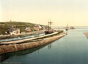
- It made the tricky harbour at Bude safer for ships.
- It built a wide canal section, about 2 miles (3.2 km) long. This part could handle large barges up to 50 feet (15 m) long.
- It created a network of narrower waterways for special small boats called tub boats. These boats were 20 feet (6.1 m) long and 5 feet 6 inches (1.68 m) wide.
- It built a reservoir at Virworthy (now called Lower Tamar Lake) to supply water to the canal.
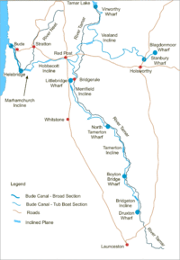
The main canal line went southeast from Bude towards Launceston. There was also an eastern branch to Blagdonmoor and a northern branch from the Virworthy reservoir.
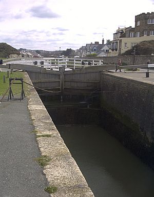
The two traditional locks were in the short, wide canal section. Each lock raised or lowered boats by 5 feet 6 inches (1.68 m). This section ended at Helebridge, about 2 miles (3.2 km) from Bude. Larger coastal barges could travel this far.
The smaller tub boats were designed for the rest of the canal system. They could travel from Bude harbour or transfer from larger ships at Helebridge.
After Helebridge, boats faced three inclined planes to reach the highest part of the canal. This central section was 433 feet (132 m) above sea level. The main line to Launceston then went down three more inclined planes.
Because there were no locks on the tub boat sections, the canal had to follow the land's curves. This made its path very winding. Even so, impressive bridges and earthworks were built to cross streams and valleys.
The Amazing Inclined Planes
The most unique part of the Bude Canal was its six inclined planes. These were ramps where the tub boats, which had wheels, were pulled up or let down. The wheels ran in special U-shaped rails. Each plane had two sets of rails, one for each direction.
Chains pulled the tub boats up and down the slopes. In most cases, large waterwheels powered these chains. A trip up or down usually took about five minutes. Some planes also had steam engines as backup.
The Hobbacott Inclined Plane was the steepest and had the biggest height change. It used a clever water-powered system. A very large bucket was filled with water. The weight of this water pulled an ascending tub boat up the ramp. The bucket went down a deep shaft. At the bottom, a plug opened, and the water flowed away. As the full bucket went down, it also pulled an empty bucket up. This system was very efficient, raising a boat in about four minutes. This was twice as fast as using the backup steam engine!
| Name | Vertical Change | Length | Power System |
|---|---|---|---|
| Marhamchurch | 120 ft (37 m) | 836 ft (255 m) | Overshot waterwheel |
| Hobbacott | 225 ft (69 m) | 935 ft (285 m) | Descending bucket |
| Vealand | 58 ft (18 m) | 500 ft (150 m) | Overshot waterwheel |
| Merrifield | 60 ft (18 m) | 360 ft (110 m) | Overshot waterwheel |
| Tamerton | 59 ft (18 m) | 360 ft (110 m) | Overshot waterwheel |
| Bridgetown | 51 ft (16 m) | 259 ft (79 m) | Overshot waterwheel |
The steepness of the planes varied. Hobbacott was the steepest, while Vealand was the gentlest.
Tub Boats: The Canal's Workhorses
The tub boats were 20 feet (6.1 m) long and 5 feet 6 inches (1.68 m) wide. Each could carry about 20 tons of goods. These boats were not just used on the Bude Canal. They were common on other canals too.
Usually, four to six tub boats were linked together. Horses then pulled this "train" of boats. A train could be up to 120 feet (37 m) long! This must have been tricky to steer around the canal's many sharp bends. Sailors could adjust the connections between boats to help with steering.
Each boat had four wheels, 14 inches (36 cm) across. These wheels were for running on the inclined planes. Boats were pulled up and down the planes one at a time. It must have been quite a challenge to line up the boats perfectly with the rails when moving them from the water to the ramp!
Life and Decline of the Canal
After it was built, the canal company often struggled for money. The income never reached the high amounts people hoped for. Also, there were many problems with the newly built canal. Chains on the inclined planes often broke, and rails snapped. Careless boat handling also caused damage.
Despite these issues, the canal successfully carried huge amounts of rich sand to farms. It also transported other goods, especially coal from South Wales. Traffic actually increased in the 1880s. When the London and South Western Railway reached Holsworthy, the canal carried a lot of sand to Stanbury Wharf. From there, it went by railway.
However, the arrival of railways eventually led to the canal's downfall. Factory-made fertilisers became common and cheap. They could be brought in by train, so farmers needed less of the local sand.
It became clear the canal could not survive. Some leaders wanted to close it or sell it to the railway company. But legal agreements meant some landowners had rights to use the canal's water. They wouldn't give up these rights easily. Finally, the tub boat operations stopped on 14 November 1891. The main lines were closed, but the Feeder arm stayed open for water rights.
In 1902, the local council bought the rest of the canal. This allowed them to use the canal's reservoir to supply drinking water to nearby villages.
The Bude Canal Today
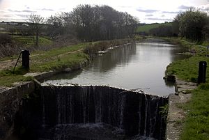
Today, the sea lock at Bude still works. The canal has water as far as the first inclined plane. However, the sea lock is the only working lock in this section. So, you can't navigate the entire canal network. Much of the upper canal has been ploughed over or is overgrown. But you can still find many signs of the canal. These include old bridges and wharf buildings. On maps, you can see where the feeder branch and lower main line used to be. Most of the old canal path is not open to the public.
Plans for Restoration
In 2005, big plans were approved to improve the canal. This included fixing the two locks between the sea lock and the first inclined plane. A lot of money, £3.8 million, was given for this project. Most of the planned work was finished by March 2009.
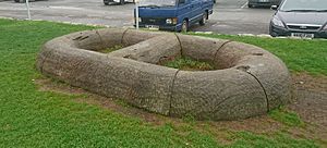
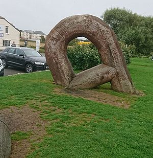
One part of the restoration involved creating wooden sculptures by Daniel Sodhi-Miles. These sculptures look like chains or parts of chains. They remind people of the canal's history. They are also carved with words and phrases in both Cornish and English.
March 2008 Storm Damage
On Monday, 10 March 2008, a strong storm hit the canal. It ripped one of the lock gates off its hinges. Workers quickly removed the damaged gate. They placed large concrete pipes in the canal basin to stop strong waves from the sea. A temporary dam was built at Falcon Bridge. Anglers and environmental staff rescued fish before they were swept out to sea.
Beyond the dam, water levels only dropped a little. But the lower end of the canal became almost empty. This revealed some interesting things in the mud, including an old shotgun!
The local council used this chance to fix the canal walls and clean out the basin. They removed over 6,000 cubic meters (7,800 cu yd) of silt. The basin was supposed to be refilled slowly after 8 July 2008. But heavy rain before that date caused a rush of water. This damaged the temporary dam, and the basin refilled in just one day.
Images for kids
 | Audre Lorde |
 | John Berry Meachum |
 | Ferdinand Lee Barnett |


