Bull Run Hydroelectric Project facts for kids
Quick facts for kids Marmot Dam and Little Sandy Dam |
|
|---|---|

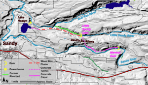
Map of the components of the Bull Run Hydroelectric Project
|
|
| Official name | Bull Run Hydroelectric Project |
| Country | United States |
| Location | Oregon |
| Coordinates | 45°25′44″N 122°14′02″W / 45.42901°N 122.23395°W |
| Purpose | Power generation |
| Status | Decommissioned |
| Construction began | 1908 |
| Opening date | 1912 |
| Demolition date | 2007-2008 |
| Owner(s) | Portland General Electric |
| Reservoir | |
| Creates | Roslyn Lake |
| Total capacity | 928 acre-feet (1,145,000 m3) |
| Power station | |
| Installed capacity | 22 MW |
| Annual generation | 110,000 MW·h (400 TJ) |
The Bull Run Hydroelectric Project was a system of dams and canals in Oregon, USA. It was built by Portland General Electric (PGE) to create hydroelectric power. This means it used the force of flowing water to make electricity.
The project started operating in 1912 and provided power to the Portland area for almost 100 years. It included two main dams: Marmot Dam on the Sandy River and Little Sandy Dam on the Little Sandy River. These dams were removed in 2007 and 2008 because of growing environmental concerns.
Contents
Building a Powerhouse: The Bull Run Project
The project began in 1906 with the Mount Hood Railway and Power Company. They built the Little Sandy Dam first. This dam sent water through a long wooden channel, called a flume, to a lake called Roslyn Lake.
Roslyn Lake was like a big storage tank for water. It was about 140 acres in size. The water from the lake then flowed to the powerhouse, where electricity was made. The powerhouse started working in 1912.
Early Days: Dams and Water Flow
In 1913, another dam was built on the Sandy River. This was the Marmot Dam, which was about 45 feet (14 meters) high. It helped send even more water to the Little Sandy River.
The water then traveled through a long tunnel to reach the Little Sandy River. From there, it joined the water already flowing to Roslyn Lake. This system made sure the powerhouse had enough water to generate power.
Helping Fish: Ladders and Screens
When Marmot Dam was built, it included a special fish ladder. This ladder was supposed to help fish like salmon and steelhead swim upstream past the dam. However, it didn't work very well at first and needed many repairs.
Later, PGE also added special screens to stop fish from being swept into the water canals. They even added a bypass system to help rescue any fish that got trapped. In 1989, the original wooden Marmot Dam was replaced with a stronger concrete one.
Powering Homes: How it Worked
The powerhouse at the Bull Run Project was very powerful. It could generate 22 megawatts (MW) of electricity. This was enough power to supply about 12,000 homes back in 2007.
The water from Roslyn Lake flowed down large pipes called penstocks to spin turbines. These turbines then powered generators to create electricity.
Taking Down the Dams: A Big Decision
Removing the Bull Run Project was a huge undertaking. Marmot Dam was one of the largest concrete dams ever removed in the United States. Many groups worked together to plan how to take it down safely.
Why the Dams Were Removed
PGE decided to remove the dams because of the high costs of protecting the environment. The dams were blocking fish from swimming freely in the rivers. This was especially a problem for salmon and steelhead, which need to travel upstream to lay their eggs.
The company realized that the money needed to protect the fish and their homes was more than the money they made from the electricity. So, they decided to let the rivers flow naturally again.
The Removal Process
The removal of Marmot Dam began in July 2007. First, a temporary dam was built upstream to redirect the river. Then, parts of the concrete dam were carefully blown up. The rest of the dam was broken apart using special tools over several months.
By October 2007, Marmot Dam was completely gone. The Sandy River was able to flow freely for the first time since 1912. The Little Sandy Dam was removed in 2008, and Roslyn Lake was drained.
A New Future for the River
Removing the dams had a great impact on the rivers. The Little Sandy River now flows freely, and fish can swim upstream again. Just a year after the dams were removed, biologists saw salmon and steelhead spawning in areas that were once blocked.
PGE also donated a large piece of land near the dam site. This land is now part of a natural refuge and public recreation area. It helps protect the environment and gives people a place to enjoy nature.
Preserving History: The Powerhouse
Even though the dams were removed, the historic powerhouse building was saved. A group of people interested in preserving old buildings bought it. They plan to protect the powerhouse and other nearby structures.
In 2012, an event was held to celebrate the powerhouse's 100th anniversary. Many visitors came, including former employees who shared their stories. In 2014, the area around the powerhouse was named a Historic District. This helps make sure these important buildings are protected for the future.

