Little Sandy River (Oregon) facts for kids
Quick facts for kids Little Sandy River |
|
|---|---|

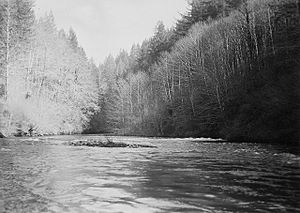
The Little Sandy River in March 1940
|
|

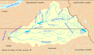
Bull Run River watershed
|
|
|
Location of the mouth of the Little Sandy River in Oregon
|
|
| Country | United States |
| State | Oregon |
| County | Clackamas County |
| Physical characteristics | |
| Main source | Mount Hood National Forest Near Hickman Butte, west of Mount Hood, Clackamas County, Oregon 3,383 ft (1,031 m) 45°24′13″N 121°55′58″W / 45.40361°N 121.93278°W |
| River mouth | Bull Run River near Bull Run, Clackamas County, Oregon 449 ft (137 m) 45°25′34″N 122°12′24″W / 45.42611°N 122.20667°W |
| Length | 15 mi (24 km) |
| Basin features | |
| Basin size | 22.3 sq mi (58 km2) |
The Little Sandy River is a river in Oregon, United States. It is about 15 miles (24 km) long. This river flows into the Bull Run River.
The Little Sandy River starts west of Mount Hood in the Mount Hood National Forest. It flows mostly west, running somewhat next to the Sandy River to its south. The entire river is in Clackamas County. Most of its path and the smaller streams that feed it are inside a special protected area. This area is called the Bull Run Watershed Management Unit (BRWMU). It helps protect the main water supply for the city of Portland.
In 2008, a company called Portland General Electric (PGE) took down the Little Sandy Dam. This was the only dam on the river. Removing the dam allowed fish like salmon and steelhead to swim up the river again. They had not been able to do this for almost 100 years! In 2009, people saw both types of fish laying their eggs (spawning) above where the dam used to be.
Contents
River's Journey
The Little Sandy River begins in the Mount Hood National Forest, southeast of a place called Hickman Butte. It flows northwest between North Mountain on its left side and Goodfellow Lakes on its right side.
Then, the river turns west. It passes south of some hills called Aschoff Buttes. Along its way, it gets water from two smaller streams, Bow Creek and Arrow Creek, both from its right side.
Where the River Meets the Bull Run
As the river gets closer to its end, a ridge called the Devil's Backbone separates it from the Sandy River to the south. The Little Sandy River passes the spot where the Little Sandy Dam used to be. It then flows into the Bull Run River. This meeting point is about 2 miles (3.2 km) from where the Bull Run River joins the Sandy River.
From where it starts to where it ends, the river drops about 2,934 feet (894 m) in height. This means it drops about 196 feet (60 m) for every mile it travels.
Protected Water Supply
Most of the Little Sandy River's path is inside the Bull Run Watershed Management Unit (BRWMU). This is a special area of 143 square miles (370 km2) that is protected by the government. It provides the main drinking water for Portland.
Because it's a water source, most people are not allowed to enter the BRWMU. Only government workers and special guests on official business can go in. Security guards watch over the three gated entrances to keep the water safe. In 1996, the U.S. Congress stopped commercial logging (cutting down trees for money) in this area. Later, in 2001, a law called the Little Sandy Act made sure that logging was also banned in all federal lands that drain into the Little Sandy River and the lower Bull Run River.
River Flow Measurements
The United States Geological Survey (USGS) has a special device called a stream gauge that measures how much water flows in the Little Sandy River. This gauge is located about 1.95 miles (3.14 km) from where the river meets the Bull Run River.
Over 89 years (from 1920 to 2008), the river's average flow at this spot was 143 cubic feet per second (4.0 m3/s). This measurement comes from a drainage area of 22.3 square miles (58 km2).
- The most water ever recorded flowing through the gauge was 5,320 cubic feet per second (151 m3/s) on November 20, 1921.
- The least amount of water recorded was 8 cubic feet per second (0.23 m3/s) on August 20 and September 16 and 17, 1940.
The Little Sandy Dam Story
For many years, from 1912 to 2008, the flow of the Little Sandy River was changed by a project called the Bull Run Hydroelectric Project. This project took water from the Sandy River at a dam called Marmot Dam. Then, it sent that water to the Little Sandy River at the Little Sandy Dam.
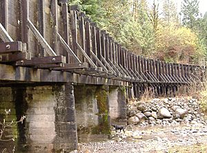
From the Little Sandy Dam, water was moved through a long wooden box called a flume. This flume carried the water to an artificial lake called Roslyn Lake. Roslyn Lake then supplied water to the Bull Run hydroelectric powerhouse, which made electricity. After making power, the water flowed into the Bull Run River.
Dam Removal and Fish Return
In July 2007, engineers took down the Marmot Dam, which was 47-foot (14 m) high. Then, in 2008, they removed the Little Sandy Dam, which was 16-foot (4.9 m) high. Once these dams were gone, Roslyn Lake also disappeared.
Removing these dams was a big deal! It meant that steelhead and salmon could swim freely up the Little Sandy River again. They had not been able to reach these parts of the river for almost 100 years.
The company that owned the dams, PGE, gave 1,500 acres (6.1 km2) of land near the dams to a group called the Western Rivers Conservancy. This land is now a nature reserve and a place where people can enjoy the outdoors. In May 2009, a scientist who studies fish reported that salmon and steelhead were indeed laying their eggs upstream of where the dams used to be.
 | Sharif Bey |
 | Hale Woodruff |
 | Richmond Barthé |
 | Purvis Young |


