Bullaring, Western Australia facts for kids
Quick facts for kids BullaringWestern Australia |
|
|---|---|

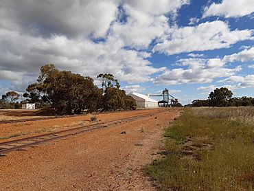
Bullaring grain receival point
|
|
| Postcode(s) | 6373 |
| Elevation | 286 m (938 ft) |
| Area | [convert: needs a number] |
| Location | |
| LGA(s) | Shire of Corrigin |
| State electorate(s) | Central Wheatbelt |
| Federal Division(s) | O'Connor |
Bullaring is a small and quiet town. You can find it in the Wheatbelt region of Western Australia. It's part of the Shire of Corrigin.
Discover Bullaring
Bullaring became an official town in 1914. It is located right along a railway line. This railway connects the towns of Corrigin and Wickepin.
What's in a Name?
The name "Bullaring" comes from the Aboriginal people. It is the name of a natural spring nearby. A spring is a place where water flows out of the ground. The exact meaning of the word "Bullaring" is not known today.
Farming in Bullaring
The main activity in Bullaring is wheat farming. Farmers grow lots of wheat in the fields around the town. Bullaring is also a special place called a "receival site." This means it's where farmers bring their harvested grain. Large companies like Cooperative Bulk Handling collect and store the grain here.
 | Anna J. Cooper |
 | Mary McLeod Bethune |
 | Lillie Mae Bradford |


