
Bunia facts for kids
Quick facts for kids
Bunia
|
|
|---|---|
|
Provincial capital and city
|
|
| Ville de Bunia | |

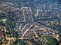
Bunia from the air, looking north toward the Nyakasanza district
|
|

Bunia
Location in Democratic Republic of the Congo
|
|
| Country | |
| Province | Ituri |
| Area | |
| • City | 576 km2 (222 sq mi) |
| • Urban | 53 km2 (20 sq mi) |
| Elevation | 1,277 m (4,190 ft) |
| Population
(2015)
|
|
| • City | 900,666 |
| • Density | 1,563.7/km2 (4,050/sq mi) |
| • Urban | 486,000 |
| • Urban density | 9,170/km2 (23,750/sq mi) |
| Time zone | UTC+2 (Central Africa Time) |
| Climate | Af |
| National language | Swahili |
Bunia is an important city in the Democratic Republic of the Congo (DRC). It is the capital of Ituri Province. Before, it was part of a larger province called Orientale.
The city sits on a high plateau, about 1,275 meters (4,183 feet) above sea level. It is located about 30 kilometers (19 miles) west of Lake Albert. This lake is part of the Albertine Rift, a huge valley system. Bunia is also about 25 kilometers (16 miles) east of the Ituri Rainforest.
Bunia has been a central point in the Ituri conflict. This was a period of disagreements between different groups of people, the Lendu and Hema. During the Second Congo War, there was a lot of fighting and many people were affected. Because of this, Bunia became a base for one of the largest United Nations peace-keeping forces in Africa. These forces help keep the peace. The area around Bunia has natural resources like gold mines, which have been a reason for some of the past conflicts.
Contents
What is Bunia's Climate Like?
Bunia has a tropical rainforest climate. This means it is warm, humid, and wet all year round. Even in the driest months, from December to February, it still rains a lot. For most of the year, from March to November, the rainfall is very heavy.
| Climate data for Bunia | |||||||||||||
|---|---|---|---|---|---|---|---|---|---|---|---|---|---|
| Month | Jan | Feb | Mar | Apr | May | Jun | Jul | Aug | Sep | Oct | Nov | Dec | Year |
| Mean daily maximum °C (°F) | 29.4 (84.9) |
28.9 (84.0) |
28.9 (84.0) |
28.3 (82.9) |
27.2 (81.0) |
26.1 (79.0) |
25.6 (78.1) |
26.1 (79.0) |
27.2 (81.0) |
27.2 (81.0) |
27.2 (81.0) |
28.3 (82.9) |
27.5 (81.5) |
| Daily mean °C (°F) | 22.8 (73.0) |
22.8 (73.0) |
22.8 (73.0) |
22.8 (73.0) |
22.2 (72.0) |
20.8 (69.4) |
20.6 (69.1) |
20.6 (69.1) |
21.1 (70.0) |
21.4 (70.5) |
21.1 (70.0) |
22.0 (71.6) |
21.8 (71.2) |
| Mean daily minimum °C (°F) | 16.1 (61.0) |
16.7 (62.1) |
16.7 (62.1) |
17.2 (63.0) |
17.2 (63.0) |
15.6 (60.1) |
15.6 (60.1) |
15.0 (59.0) |
15.0 (59.0) |
15.6 (60.1) |
15.0 (59.0) |
15.6 (60.1) |
15.9 (60.6) |
| Average rainfall mm (inches) | 139.7 (5.50) |
172.7 (6.80) |
238.8 (9.40) |
269.3 (10.60) |
317.5 (12.50) |
266.7 (10.50) |
309.9 (12.20) |
393.7 (15.50) |
243.8 (9.60) |
274.3 (10.80) |
304.8 (12.00) |
165.1 (6.50) |
3,096.3 (121.9) |
How People Travel in Bunia
The main dirt roads that connect northeastern DR Congo to other cities like Kisangani and Butembo pass through Bunia. However, these roads are often in poor condition. They can be very difficult to use, especially after heavy rains.
Bunia is only about 40 kilometers (25 miles) from the border with Uganda, near Lake Albert. But there are no direct roads across the Great Rift Valley to Ugandan towns. Instead, a dirt road goes northeast to Arua and Gulu in Uganda. Before conflicts made this route unsafe, it was a major trade path between the DRC and Uganda. It also connected to Juba in South Sudan. Bunia was an important market city for trade both within the country and across borders.
The idea of a very long highway, the Lagos-Mombasa Highway, passes near Bunia. This shows that Bunia could be a big center for trade. However, this highway is not fully built or easy to use through the DRC.
Bunia is also connected to a small port called Kasenyi on Lake Albert. This connection is a 60-kilometer (37-mile) dirt track. From Kasenyi, boats can travel to other places on Lake Albert.
Because the roads are not very good and there are no trains, Bunia Airport is extremely important for travel and transport.
Bunia's Population Growth
Bunia is growing quickly! Experts predicted it would be one of the fastest-growing cities in Africa between 2020 and 2025. Its population was expected to grow by about 5.63% each year.
Other Interesting Facts About Bunia

Mount Hoyo is about 35 kilometers (22 miles) southwest of Bunia. The Shari River flows along the northwestern edge of the city. The Ituri River is about 35 kilometers (22 miles) west of Bunia. These two rivers meet about 45 kilometers (28 miles) south-southwest of Bunia.
Even though Bunia is about 170 kilometers (106 miles) north of the Equator, it was shown in a TV show called Equator. This was because it was one of the few safe places near the Equator in eastern DRC for the TV crew to film. This safety was thanks to the large UN peace-keeping force stationed there.
Learning and Education in Bunia
Bunia has several universities. The biggest one is the University of Bunia (UNIBU). There is also a private university called Université Shalom de Bunia (USB). This university has the largest library in Bunia, with about 40,000 books. It even has an online catalog where you can search for books.
Images for kids
-
Bunia from the air, looking north toward the Nyakasanza district
See also
 In Spanish: Bunia para niños
