Burbank, Oklahoma facts for kids
Quick facts for kids
Burbank, Oklahoma
|
|
|---|---|

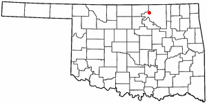
Location of Burbank, Oklahoma
|
|
| Country | United States |
| State | Oklahoma |
| County | Osage |
| Area | |
| • Total | 0.34 sq mi (0.87 km2) |
| • Land | 0.33 sq mi (0.86 km2) |
| • Water | 0.00 sq mi (0.01 km2) |
| Elevation | 971 ft (296 m) |
| Population
(2020)
|
|
| • Total | 123 |
| • Density | 370.48/sq mi (142.87/km2) |
| Time zone | UTC-6 (Central (CST)) |
| • Summer (DST) | UTC-5 (CDT) |
| ZIP code |
74633
|
| Area code(s) | 539/918 |
| FIPS code | 40-09950 |
| GNIS feature ID | 2411743 |
Burbank is a small town in western Osage County, Oklahoma, United States. In 2020, about 123 people lived there.
Contents
History of Burbank
Burbank was started in 1903 on the land of the Osage people. A man named Anthony "Gabe" Carlton founded the town. He named it after an artist, Elbridge Ayer Burbank, who was famous for painting Native American tribes.
At first, Burbank was a quiet town with about 200 residents. Its economy was based on farming and ranching. But everything changed in May 1920 when a lot of oil was discovered nearby! This made Burbank a "boom town." A boom town is a place that grows very fast because of a sudden increase in business, like finding oil.
The oil field near Burbank was huge. It stretched about 20 miles (32 km) long and 10 miles (16 km) wide. Because of the oil, Burbank's population quickly grew to 3,000 people. Other towns, like Whizbang, also appeared overnight to help with the oil rush.
Many big oil companies wanted to drill for oil in the Burbank field. They got permission to use the land from the Osage people. These permissions, called leases, were often sold at auctions. These auctions were held under a special tree known as the "Million Dollar Elm" in Pawhuska. Pawhuska was the main town and capital of the Osage Nation.
At these auctions, people would often bid more than a million dollars for the rights to drill for oil on just 160 acres (65 hectares) of land. Famous oilmen like E.W. Marland and Frank Phillips would stand under the Elm tree and make their bids.
Oil production in the Burbank field grew very quickly. In 1920, it produced about 134,408 barrels of oil. By 1923, it reached its highest point, producing over 26 million barrels! However, by 1926, production had dropped by half. By 1930, the oil boom was over. Burbank's population also dropped to 372 people that year. During its busiest time, the Burbank oil field produced about 160 million barrels of oil, worth almost $286 million.
The Osage tribe and its members received a lot of money from the oil. They got about $45 million in royalties in the 1920s. Unlike many other tribes, the Osage had kept the rights to the minerals under their land. This meant they earned money from the oil found there. Osage members who were on the 1906 tribal roll could receive up to $15,000 each year from oil royalties. This was a lot of money back then, equal to more than $150,000 in today's money. Because of this, the Osage were known as "the richest people in the world."
By 2002, the number of people living in Burbank had become much smaller. In the past, Burbank had a grocery store, two movie theaters, and two hotels.
Geography of Burbank
Burbank is located about 22 miles (35 km) west of Pawhuska. It is also about 122 miles (196 km) northeast of Oklahoma City.
The town covers a total area of about 0.3 square miles (0.8 square kilometers). Almost all of this area is land.
Population Information
| Historical population | |||
|---|---|---|---|
| Census | Pop. | %± | |
| 1930 | 372 | — | |
| 1940 | 329 | −11.6% | |
| 1950 | 268 | −18.5% | |
| 1960 | 238 | −11.2% | |
| 1970 | 188 | −21.0% | |
| 1980 | 161 | −14.4% | |
| 1990 | 165 | 2.5% | |
| 2000 | 155 | −6.1% | |
| 2010 | 141 | −9.0% | |
| 2020 | 123 | −12.8% | |
| U.S. Decennial Census | |||
In 2000, there were 155 people living in Burbank. There were 63 households and 40 families. The population density was about 459 people per square mile (177 people per square kilometer).
The average household had about 2.46 people. The average family had about 3.20 people. About 33.5% of the people in town were under 18 years old. The median age was 36 years.
Education
Parts of Burbank are served by different school districts. The southern part of the community is in Woodland Public Schools. The northern part is in Shidler Public Schools.
Burbank used to have its own school district, called Burbank School District 20. A school opened in Burbank around 1904. The high school closed in 1968. In 2002, the entire school district and its K-8 school closed down. Its students then went to schools in Shidler, Woodland, and Ponca City Public Schools.
Notable Person
- Hub Andrews, a baseball player
See also
 In Spanish: Burbank (Oklahoma) para niños
 | Bessie Coleman |
 | Spann Watson |
 | Jill E. Brown |
 | Sherman W. White |

