Burdette, Arkansas facts for kids
Quick facts for kids
Burdette, Arkansas
|
|
|---|---|

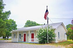
Post office and Burdette Farms office
|
|

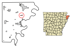
Location in Mississippi County, Arkansas
|
|
| Country | United States |
| State | Arkansas |
| County | Mississippi |
| Incorporated | May 10, 1905 |
| Named for | Alfred Burdette Wolverton |
| Area | |
| • Total | 0.74 sq mi (1.91 km2) |
| • Land | 0.74 sq mi (1.91 km2) |
| • Water | 0.00 sq mi (0.00 km2) |
| Elevation | 240 ft (70 m) |
| Population
(2020)
|
|
| • Total | 140 |
| • Density | 189.96/sq mi (73.31/km2) |
| Time zone | UTC-6 (Central (CST)) |
| • Summer (DST) | UTC-5 (CDT) |
| ZIP code |
72321
|
| Area code(s) | 870 |
| FIPS code | 05-09880 |
| GNIS feature ID | 2405344 |
Burdette is a small town in Mississippi County, Arkansas, United States. In 2020, about 140 people lived there. This was a bit less than the 191 people who lived there in 2010.
History of Burdette
Burdette started as a special kind of town called a company town in the early 1900s. This means a company, the Three States Lumber Company, built and owned most of the town.
The town officially became a town in 1905. It was named after Alfred Burdette Wolverton, who was an early logger in the area. The Three States Lumber Company built a very large sawmill in Burdette in 1906.
A railway line was also built to help move lumber. In 1907, the Blytheville, Burdette and Mississippi River Railway was created. This railway connected Burdette to Wolverton Landing on the Mississippi River and also went north to Blytheville.
Besides lumber, farming was also very important. A large farm called the Burdette Plantation grew alongside the lumber business. Starting in the 1920s, the University of Arkansas used these farms for agricultural research. They worked on making cotton and corn crops better. New types of cotton, like "Burdette Express" and "Burdette Lone Star," were created in this area.
Where is Burdette?
Burdette is located in the northeastern part of Mississippi County. You can find it along Arkansas Highway 148. It's about 5 miles (8 km) north of Luxora and 9 miles (14 km) south of Blytheville. The town is also about 5 miles (8 km) northwest of the Mississippi River.
The town's borders stretch from Interstate 55 in the west to U.S. Route 61 in the east. The United States Census Bureau says that Burdette covers an area of about 0.74 square miles (1.91 square kilometers), and all of it is land.
People in Burdette
| Historical population | |||
|---|---|---|---|
| Census | Pop. | %± | |
| 1920 | 100 | — | |
| 1930 | 155 | 55.0% | |
| 1940 | 110 | −29.0% | |
| 1950 | 122 | 10.9% | |
| 1960 | 115 | −5.7% | |
| 1970 | 173 | 50.4% | |
| 1980 | 328 | 89.6% | |
| 1990 | 148 | −54.9% | |
| 2000 | 129 | −12.8% | |
| 2010 | 191 | 48.1% | |
| 2020 | 140 | −26.7% | |
| U.S. Decennial Census 2014 Estimate |
|||
In 2010, there were 191 people living in Burdette. Most of the people were White (70.7%), and about 20.9% were Black. About 8.4% of the people were Hispanic or Latino.
In 2000, the town had 129 people. Most residents were White (82.17%), and 17.05% were Black or African American.
Schools in Burdette
Students in Burdette attend schools that are part of the Blytheville School District. This includes Blytheville High School. The Burdette school district joined with the Blytheville district in 1971.
See also
 In Spanish: Burdette (Arkansas) para niños
 | Isaac Myers |
 | D. Hamilton Jackson |
 | A. Philip Randolph |

