Blytheville, Arkansas facts for kids
Quick facts for kids
Blytheville, Arkansas
|
|
|---|---|

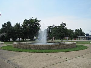
Blytheville City Park
|
|

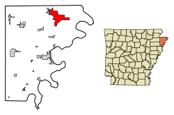
Location in Mississippi County, Arkansas
|
|
| Country | United States |
| State | Arkansas |
| County | Mississippi |
| First settled: | 1880 |
| Established: | January 4, 1892 |
| Named for | Reverend Henry T. Blythe (1816–1904) |
| Area | |
| • Total | 20.80 sq mi (53.87 km2) |
| • Land | 20.74 sq mi (53.71 km2) |
| • Water | 0.06 sq mi (0.16 km2) |
| Elevation | 256 ft (78 m) |
| Population
(2020)
|
|
| • Total | 13,406 |
| • Density | 646.45/sq mi (249.60/km2) |
| Time zone | UTC-6 (Central (CST)) |
| • Summer (DST) | UTC-5 (CDT) |
| ZIP codes |
72315, 72316, 72319
|
| Area code(s) | 870 |
| FIPS code | 05-07330 |
| GNIS feature ID | 2403885 |
Blytheville is a city in Mississippi County, Arkansas, United States. It is one of the two main cities that serve as the county seat for the county. This means it's an important center for local government. Blytheville is about 60 miles (97 km) north of West Memphis. In 2020, about 13,406 people lived there.
Contents
History of Blytheville
Blytheville was started in 1879 by a clergyman named Henry T. Blythe. A post office opened the same year. The town officially became a city in 1889. In 1901, it became the county seat for the northern part of Mississippi County. Blytheville got telephone service and electricity in 1903, and natural gas in 1950.
Early Industries
One of the first big industries in Blytheville was lumber. Many trees were cut down to help rebuild Chicago after a huge fire in 1871. This brought sawmills to the area. The Paragould Southeastern Railway arrived in 1907, which helped move the lumber.
After the forests were cleared, cotton farming became very important. The population grew a lot after 1900 because of this. Today, Blytheville has one of the largest cotton gins in North America. Soybeans and rice are also big crops here.
Military and Steel Industries
In 1942, an "advanced" pilot training school for the Army Air Forces was built northwest of town. It was used to train pilots during World War II. After the war, it became the city's airport for a short time.
The former military base was reopened in 1956 as Blytheville Air Force Base. It was an important base during the Cold War, hosting the 97th Wing until it closed in 1992.
In the 1980s, Blytheville started to grow its industrial side, especially with the steel industry. Nucor Steel opened a large plant near Blytheville in 1987.
City Leadership
In 2011, James Sanders became the first African-American mayor of Blytheville. After he retired in 2023, Melissa Logan was elected. She is the city's first female Black mayor.
Geography and Climate
Blytheville is in the northeastern part of Arkansas and Mississippi County. It is the easternmost city in Arkansas. The state line for Missouri is about 5 miles (8 km) north. The Mississippi River, which forms the border with Tennessee, is about 8 miles (13 km) east.
The city covers about 20.8 square miles (53.9 km²). A very small part of this area, about 0.06 square miles (0.16 km²), is water.
Climate in Blytheville
Blytheville has a humid subtropical climate. This means it has hot, humid summers. Winters are usually mild to cool.
| Climate data for Blytheville, Arkansas, 1991–2020 normals, extremes 1926–2013 | |||||||||||||
|---|---|---|---|---|---|---|---|---|---|---|---|---|---|
| Month | Jan | Feb | Mar | Apr | May | Jun | Jul | Aug | Sep | Oct | Nov | Dec | Year |
| Record high °F (°C) | 79 (26) |
80 (27) |
88 (31) |
94 (34) |
99 (37) |
109 (43) |
109 (43) |
107 (42) |
106 (41) |
99 (37) |
88 (31) |
79 (26) |
109 (43) |
| Mean maximum °F (°C) | 66.7 (19.3) |
71.4 (21.9) |
78.4 (25.8) |
85.7 (29.8) |
90.9 (32.7) |
97.1 (36.2) |
98.3 (36.8) |
98.0 (36.7) |
93.7 (34.3) |
86.2 (30.1) |
77.8 (25.4) |
67.4 (19.7) |
99.9 (37.7) |
| Mean daily maximum °F (°C) | 45.3 (7.4) |
50.5 (10.3) |
59.6 (15.3) |
70.6 (21.4) |
79.7 (26.5) |
88.0 (31.1) |
90.1 (32.3) |
89.0 (31.7) |
83.4 (28.6) |
72.5 (22.5) |
59.1 (15.1) |
48.9 (9.4) |
69.7 (21.0) |
| Daily mean °F (°C) | 37.5 (3.1) |
42.0 (5.6) |
50.6 (10.3) |
61.0 (16.1) |
70.5 (21.4) |
78.8 (26.0) |
81.3 (27.4) |
79.9 (26.6) |
73.4 (23.0) |
62.2 (16.8) |
50.2 (10.1) |
41.2 (5.1) |
60.7 (16.0) |
| Mean daily minimum °F (°C) | 29.8 (−1.2) |
33.5 (0.8) |
41.6 (5.3) |
51.4 (10.8) |
61.3 (16.3) |
69.7 (20.9) |
72.5 (22.5) |
70.8 (21.6) |
63.5 (17.5) |
51.9 (11.1) |
41.4 (5.2) |
33.5 (0.8) |
51.7 (11.0) |
| Mean minimum °F (°C) | 12.4 (−10.9) |
16.6 (−8.6) |
25.5 (−3.6) |
35.5 (1.9) |
48.1 (8.9) |
58.7 (14.8) |
64.0 (17.8) |
61.1 (16.2) |
48.1 (8.9) |
37.3 (2.9) |
27.0 (−2.8) |
16.3 (−8.7) |
7.4 (−13.7) |
| Record low °F (°C) | −14 (−26) |
−3 (−19) |
5 (−15) |
25 (−4) |
34 (1) |
46 (8) |
51 (11) |
49 (9) |
35 (2) |
25 (−4) |
7 (−14) |
−7 (−22) |
−14 (−26) |
| Average precipitation inches (mm) | 3.85 (98) |
4.13 (105) |
4.81 (122) |
5.40 (137) |
5.90 (150) |
3.76 (96) |
4.00 (102) |
3.55 (90) |
2.76 (70) |
4.07 (103) |
4.28 (109) |
5.07 (129) |
51.58 (1,311) |
| Average snowfall inches (cm) | 0.8 (2.0) |
1.7 (4.3) |
0.2 (0.51) |
0.0 (0.0) |
0.0 (0.0) |
0.0 (0.0) |
0.0 (0.0) |
0.0 (0.0) |
0.0 (0.0) |
0.0 (0.0) |
0.0 (0.0) |
0.2 (0.51) |
2.9 (7.32) |
| Average precipitation days (≥ 0.01 in) | 10.1 | 8.0 | 10.4 | 9.8 | 10.1 | 8.1 | 7.7 | 5.6 | 5.8 | 7.6 | 10.4 | 10.3 | 103.9 |
| Average snowy days (≥ 0.1 in) | 0.7 | 0.9 | 0.1 | 0.0 | 0.0 | 0.0 | 0.0 | 0.0 | 0.0 | 0.0 | 0.0 | 0.2 | 1.9 |
| Source 1: NOAA | |||||||||||||
| Source 2: National Weather Service (mean maxima/minima 1981–2010) | |||||||||||||
People of Blytheville
The city's population has changed over the years. Here's how it has grown and shrunk:
| Historical population | |||
|---|---|---|---|
| Census | Pop. | %± | |
| 1900 | 302 | — | |
| 1910 | 3,849 | 1,174.5% | |
| 1920 | 6,447 | 67.5% | |
| 1930 | 10,098 | 56.6% | |
| 1940 | 10,652 | 5.5% | |
| 1950 | 16,234 | 52.4% | |
| 1960 | 20,797 | 28.1% | |
| 1970 | 24,752 | 19.0% | |
| 1980 | 23,844 | −3.7% | |
| 1990 | 22,906 | −3.9% | |
| 2000 | 18,272 | −20.2% | |
| 2010 | 15,620 | −14.5% | |
| 2020 | 13,406 | −14.2% | |
| U.S. Decennial Census | |||
Population in 2020
In 2020, there were 13,406 people living in Blytheville. There were 5,674 households and 3,644 families.
Here's a look at the different groups of people living in Blytheville in 2020:
| Race | Number | Percent |
|---|---|---|
| White | 4,175 | 31.14% |
| Black or African American | 8,044 | 60.0% |
| Native American | 27 | 0.2% |
| Asian | 112 | 0.84% |
| Pacific Islander | 3 | 0.02% |
| Other/Mixed | 503 | 3.75% |
| Hispanic or Latino | 542 | 4.04% |
Economy of Blytheville
The biggest employer in Blytheville and Mississippi County is Nucor Steel. They have four locations in the area. These include Nucor Yamato Steel and Nucor Steel Arkansas.
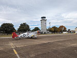
Aviation Repair Technologies (ART) has its main office at the Arkansas International Airport in Blytheville. They employ about 120 people.
Tenaris is a company that makes and supplies steel pipes. They have facilities in Blytheville that make and prepare pipes.
Fun and Culture
Blytheville offers many places for fun and learning.
Recreation
- Blytheville City Parks
- Cyprus Park
- Nelson Park
- Walker Park
- Blytheville City Pool
- Williams Park
- Blytheville Youth Sportsplex
- Thunder Bayou Golf Course
Cultural Institutions
- Adams-Vines Recital Hall (at Arkansas Northeastern College)
- Arts Council of Mississippi County
- Blytheville Book Company
- Delta Gateway Museum
- Lights of the Delta
- Main Street Blytheville
- Mississippi County Library System
- National Cold War Center - This center is being created to teach people about the Cold War. It plans to open in 2027. It will use the old Blytheville Air Force Base's Ready Alert Facility as its main exhibit.
- Ritz Civic Center
Education in Blytheville
Most students in the city attend Blytheville Public Schools. The schools are:
- Blytheville Primary School (Kindergarten to 2nd grade)
- Blytheville Elementary School (3rd to 5th grade)
- Blytheville Middle School (6th to 8th grade)
- Blytheville High School (9th to 12th grade)
Other parts of Blytheville are served by Armorel Public Schools and Gosnell Public Schools. These districts have their own high schools: Armorel High School and Gosnell High School. KIPP Delta also runs the KIPP Delta Blytheville Charter School.
Blytheville is also home to Arkansas Northeastern College. This college offers two-year programs. It was the first community college in the U.S. to have a special solar power facility.
Transportation
Several major roads pass through Blytheville. These include:
- Interstate 55
- U.S. Route 61
- U.S. Route 78
- Highway 18
- Highway 137
- Highway 151
- Highway 239
- Highway 239 Spur
The Burlington Northern Santa Fe Railroad also runs through downtown Blytheville.
Famous People from Blytheville
Many notable people have connections to Blytheville:
- Julie Adams, film and television actress
- Fred Akers, football coach
- Lawrence Babits, archaeologist
- M. C. Burton Jr., professional basketball player and doctor
- Marvin Childers, state representative
- Dee Clark, R&B singer
- Kimberly Derrick, Olympic bronze medal winner in speed skating
- Al Feldstein, Mad magazine editor
- Bob Fisher, former president of Belmont University
- George Hamilton, actor
- Eric Hill, professional football player
- Nannerl O. Keohane, former president of Duke University
- Edgar H. Lloyd, World War II Medal of Honor recipient
- Bill Michael, head football coach
- Jermey Parnell, football player
- Cecil A. Partee, Chicago treasurer and politician
- Nick Symmonds, Olympic track and field runner
- Jeff Taylor, professional basketball player
- Whiquitta Tobar, former college basketball player and lawyer
- Trent Tomlinson, country music artist
- Michael Utley, composer and singer
- Junior Walker, R&B singer and saxophonist
- Kathy Webb, member of Arkansas House of Representatives
- Ruth Whitaker, Arkansas state senator
- Barry Williamson, chairman of Texas Railroad Commission
- Jon Woods, Arkansas state senator and musician
See also
 In Spanish: Blytheville para niños
 | Leon Lynch |
 | Milton P. Webster |
 | Ferdinand Smith |


