Burekup, Western Australia facts for kids
Quick facts for kids BurekupWestern Australia |
|||||||||||||||
|---|---|---|---|---|---|---|---|---|---|---|---|---|---|---|---|
 |
|||||||||||||||
| Established | 1973 | ||||||||||||||
| Postcode(s) | 6227 | ||||||||||||||
| Elevation | 23 m (75 ft) | ||||||||||||||
| Area | [convert: needs a number] | ||||||||||||||
| Location |
|
||||||||||||||
| LGA(s) | Shire of Dardanup | ||||||||||||||
| State electorate(s) | Collie-Preston | ||||||||||||||
| Federal Division(s) | Forrest | ||||||||||||||
|
|||||||||||||||
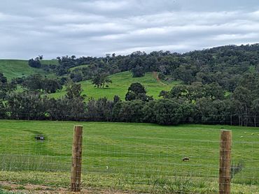
Burekup is a small, friendly town in the South West region of Western Australia. It is located right on the South Western Highway. This town is built near the beautiful Collie River.
Discover Burekup!
Burekup is a quiet town in the South West of Western Australia. It's a great place to learn about history and nature. The town is part of the Shire of Dardanup.
Where is Burekup?
Burekup is found in the South West region. It sits along the main South Western Highway. The town is also very close to the Collie River. This river adds to the natural beauty of the area.
A Bit of History
Burekup started out as a railway stop. This stop was on the line between Pinjarra and Picton. It was first set up in 1910. Back then, it was known by a slightly different name: Boorekup.
The town officially became Burekup in 1973. This happened after the local government, the Shire of Dardanup, asked for it.
How Burekup Got Its Name
The land where Burekup is located has a long history. It is the traditional home of the Noongar people. They are the original custodians of this land.
The name "Burekup" comes from the Noongar language. It is the name for a special wildflower. This beautiful flower grows naturally in the area.
 | James Van Der Zee |
 | Alma Thomas |
 | Ellis Wilson |
 | Margaret Taylor-Burroughs |


