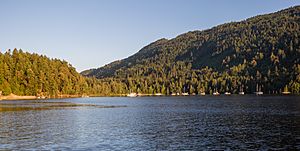
Burgoyne Bay facts for kids
Burgoyne Bay is a beautiful bay found at the southern tip of Salt Spring Island in British Columbia, Canada. It's a quiet spot where the land meets the sea, and its shores are part of the Mount Maxwell Ecological Reserve. The bay connects to Sansum Narrows, a narrow waterway that separates Saltspring Island from Vancouver Island.
Discovering Burgoyne Bay
Burgoyne Bay is a notable natural feature in the Gulf Islands region of British Columbia. It offers stunning views and is an important part of the local environment.
Where is Burgoyne Bay Located?
Burgoyne Bay is situated on the southern end of Saltspring Island. This island is one of the many beautiful islands in the Salish Sea, off the coast of mainland British Columbia. The bay opens into Sansum Narrows, which is a busy channel for boats and ferries. The land around the bay is protected as part of the Mount Maxwell Ecological Reserve, which helps keep the natural environment safe.
How Burgoyne Bay Got Its Name
Burgoyne Bay was named in 1859 by Captain George Richards. He was a British naval officer who was mapping the coast of British Columbia. Captain Richards named the bay after Hugh Talbot Burgoyne. Burgoyne was a brave officer who had received the Victoria Cross, a very high award for courage in the British military.
At the time, Hugh Talbot Burgoyne was serving on a ship called HMS Ganges. This ship was the main ship, or "flagship," of the Royal Navy's Pacific Station. The Pacific Station was a group of naval ships that protected British interests in the Pacific Ocean. Captain Richards often named places after people or ships from this naval station. For example, the nearby Fulford Harbour was named after the captain of the Ganges, and a local village called Ganges was named after the ship itself.


