Burlington, Oklahoma facts for kids
Quick facts for kids
Burlington, Oklahoma
|
|
|---|---|

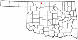
Location of Burlington, Oklahoma
|
|
| Country | United States |
| State | Oklahoma |
| County | Alfalfa |
| Area | |
| • Total | 0.27 sq mi (0.71 km2) |
| • Land | 0.27 sq mi (0.71 km2) |
| • Water | 0.00 sq mi (0.00 km2) |
| Elevation | 1,217 ft (371 m) |
| Population
(2020)
|
|
| • Total | 124 |
| • Density | 454.21/sq mi (175.66/km2) |
| Time zone | UTC-6 (Central (CST)) |
| • Summer (DST) | UTC-5 (CDT) |
| ZIP code |
73722
|
| Area code(s) | 580 |
| FIPS code | 40-10050 |
| GNIS feature ID | 2411744 |
Burlington is a small town in the northwestern part of Alfalfa County, Oklahoma, in the United States. In 2020, 124 people lived there.
Contents
History of Burlington
Early Days and Naming
The town of Burlington was first called "Drumm." It was named after a famous cattle rancher, Major Andrew Drumm. Major Drumm had a huge ranch called the U Ranch. It covered 150,000 acres from 1874 to 1888. He leased this land from the Cherokee people. He also helped start the Cherokee Strip Live Stock Association. This group was important for cattle ranching in the area. Major Drumm also founded the Andrew Drumm Institute in Independence, Missouri.
Burlington's post office opened on June 6, 1906, under the name Drumm. In July 1907, there were plans to change the town's name to "Wheaton." But this idea didn't work out. So, on August 21, 1907, the town was officially renamed Burlington. It has been called Burlington ever since.
Burlington Grain Company
In 1916, a farming business called Burlington Grain Company was started. It was a cooperative, meaning its members owned it. Today, it is known as Burlington Cooperative Association. The grain elevator in Burlington can hold 1,774,000 bushels of grain. Another storage place in nearby Amorita can hold 342,000 bushels.
School History
Alfalfa County's first combined school was created in Burlington in April 1908. The first school building was finished the next year. By 1913, the school had 150 students and four teachers. A new two-story brick building was built in 1923. In 1948, a new gym was added.
In the 1960s, several local schools joined together. The schools from Burlington, Driftwood, Byron, and Amorita all became one school district. This new district was located in Burlington. A new school building was constructed in 1963. Many additions have been made to the school since then. The newest additions, a band room and an agriculture shop, were built in 2014. Also in 2014, about 150 students from pre-kindergarten to 12th grade attended the school.
Geography and Location
Burlington is located along State Highway 8 and State Highway 11.
The town covers a total area of about 0.27 square miles (0.71 square kilometers). All of this area is land. In 2014, the town had an estimated population of 158 people. This means there were about 575 people living in each square mile.
Population Changes
The population of Burlington has changed over the years. Here is a look at how many people have lived in the town during different census years:
| Historical population | |||
|---|---|---|---|
| Census | Pop. | %± | |
| 1910 | 135 | — | |
| 1920 | 169 | 25.2% | |
| 1930 | 166 | −1.8% | |
| 1940 | 177 | 6.6% | |
| 1950 | 181 | 2.3% | |
| 1960 | 174 | −3.9% | |
| 1970 | 165 | −5.2% | |
| 1980 | 206 | 24.8% | |
| 1990 | 169 | −18.0% | |
| 2000 | 156 | −7.7% | |
| 2010 | 152 | −2.6% | |
| 2020 | 124 | −18.4% | |
| U.S. Decennial Census | |||
See also
 In Spanish: Burlington (Oklahoma) para niños
 | Lonnie Johnson |
 | Granville Woods |
 | Lewis Howard Latimer |
 | James West |

