Burns City, Indiana facts for kids
Quick facts for kids
Burns City, Indiana
|
|
|---|---|

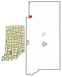
Location in Martin County, Indiana
|
|
| Country | United States |
| State | Indiana |
| County | Martin |
| Township | Perry |
| Area | |
| • Total | 0.74 sq mi (1.92 km2) |
| • Land | 0.73 sq mi (1.90 km2) |
| • Water | 0.01 sq mi (0.01 km2) |
| Elevation | 689 ft (210 m) |
| Population
(2020)
|
|
| • Total | 114 |
| • Density | 155.10/sq mi (59.91/km2) |
| Time zone | UTC-5 (Eastern (EST)) |
| • Summer (DST) | UTC-4 (EDT) |
| ZIP code |
47553 (Loogootee)
|
| Area code(s) | 812, 930 |
| GNIS feature ID | 2583447 |
Burns City is a small community in Martin County, Indiana, in the United States. It is an unincorporated community, meaning it doesn't have its own local government like a city or town. It is also a census-designated place (CDP). This means the U.S. Census Bureau counts its population. In 2020, about 114 people lived there.
Contents
History of Burns City
Burns City has an interesting past with a few name changes! The community was first started in 1849 by an early settler named Christian Keck. He called it "Keck's Church."
Around 1852, the name changed to "Kecksville." Then, on September 15, 1890, the name was officially changed to Burns City. A railroad engineer chose this name because it was his wife's maiden name.
A post office opened in 1849 under the name "Keck's Church." It was renamed Burns City in 1890. The post office served the community until it closed in 1957.
Geography and Location
Burns City is located in Perry Township. To its east, you'll find the Naval Surface Warfare Center Crane Division. This is a large U.S. Navy base.
Indiana State Road 645 starts in Burns City. This road goes west for about 1.7 miles (2.7 km) until it reaches U.S. Route 231 in Daviess County.
Land and Water
According to the U.S. Census Bureau, Burns City covers a total area of about 0.74 square miles (1.92 km2). Most of this area is land. Only a tiny part, about 0.005 square miles (0.013 km2), is water.
The community sits on a high area of land called a ridge. Water from this ridge flows in different directions. To the north, water drains into a small stream that eventually reaches the White River. To the south, water flows into Seed Tick Creek, which then joins Boggs Creek. Boggs Creek also flows into the East Fork of the White River.
Population Information
Knowing about a community's population is called demographics. It helps us understand how many people live there and how the number changes over time.
| Historical population | |||
|---|---|---|---|
| Census | Pop. | %± | |
| 2010 | 117 | — | |
| 2020 | 114 | −2.6% | |
| U.S. Decennial Census | |||
In 2010, the population of Burns City was 117 people. By 2020, the population had slightly decreased to 114 people.
See also
 In Spanish: Burns City (Indiana) para niños
 | Emma Amos |
 | Edward Mitchell Bannister |
 | Larry D. Alexander |
 | Ernie Barnes |

