Burnt Cabins, Pennsylvania facts for kids
|
Burnt Cabins Historic District
|
|

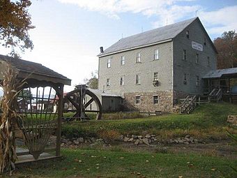
Burnt Cabins Gristmill
|
|
| Lua error in Module:Location_map at line 420: attempt to index field 'wikibase' (a nil value). | |
| Location | LR23905 and US 522, Dublin Township, Fulton County, Pennsylvania |
|---|---|
| Area | 50 acres (20 ha) |
| Architectural style | Greek Revival, Gothic Revival |
| MPS | Lincoln Highway Heritage Corridor Historic Resources: Franklin to Westmoreland Counties MPS |
| NRHP reference No. | 98000566 |
Quick facts for kids Significant dates |
|
| Added to NRHP | May 20, 1998 |
Burnt Cabins is a small, historic community in Fulton County, Pennsylvania. It sits at the base of Tuscarora Mountain. You can find it near I-76, also known as the Pennsylvania Turnpike. U.S. Route 522 also goes right through the village. This area is known for its interesting past and old buildings.
Contents
History of Burnt Cabins
Early Settlers and the Burning of Cabins
Before Europeans arrived, Native American tribes lived on this land until 1758. European settlers did not start living here permanently until 1763. This was after the French and Indian War.
However, by 1750, a small group of 11 cabins had appeared. These homes belonged to early settlers who did not have official permission to be there. The government ordered these homes to be burned. This was done to keep peace with the Native Americans. It also showed that the government respected Native American land ownership. Important people like Conrad Weiser and George Croghan were part of this event.
One story tells of a settler named Andrew Lycon. He refused to leave his cabin. Native Americans who saw this insisted his cabin be burned. So, after everything was removed, the empty cabin was set on fire. This showed how serious the government was about keeping its promises to the tribes.
Roads and Village Growth
Burnt Cabins grew as a "linear village." This means it stretched out along the roads. These roads connected Philadelphia to Pittsburgh in the 1700s. At first, the village developed along a path used by pack horses. This path followed an even older Native American trail.
In 1755, the Forbes Road was built. This road helped British troops and supplies reach Fort Duquesne. Later, in 1771, the Three Mountains Road opened. It connected Burnt Cabins more directly to Shippensburg.
By 1815, a new road called the Chambersburg and Ft. Bedford Turnpike opened. This new turnpike bypassed Burnt Cabins. Surprisingly, this helped the village. As more people moved into the county, farmers used the older, free roads to take their animals to market. This kept Burnt Cabins busy.
Historic Recognition and Local Landmarks
The entire village of Burnt Cabins is important historically. It includes about 44 buildings and covers 50 acres. In 1998, it was added to the National Register of Historic Places. This means it is recognized as a special place worth protecting.
The most important building in the village is the Burnt Cabins Grist Mill. A grist mill grinds grain into flour. This mill still makes flour today! It is also listed separately on the National Register of Historic Places.
The 1964 book Bread-and-Butter Indian by Anne Colver is set in Burnt Cabins. It tells a story based on real events from 1783.
Burnt Cabins is in the Eastern Standard Time zone. Its elevation is 889 feet above sea level.
ZIP Code Information
The Burnt Cabins ZIP code is 17215. This area covers about 11.92 square miles (30.87 square kilometers). Around 437 people live there. There are 163 housing units, and 123 of them are lived in.
See also
 In Spanish: Burnt Cabins para niños
 | Claudette Colvin |
 | Myrlie Evers-Williams |
 | Alberta Odell Jones |

