
Burren and Cliffs of Moher Geopark facts for kids
The Burren and Cliffs of Moher Geopark is a very special area in County Clare, Ireland. It's known all over the world for its amazing rocks and landscapes. This area is called a Geopark because of its unique geology. It's recognized by UNESCO, which is a big international organization.
Contents
How the Geopark Started
The idea for the Geopark began in the mid-2000s. The local government, called Clare County Council, worked with people from the community. They wanted to protect the beautiful Burren area and help visitors enjoy it.
Many groups helped out, like Fáilte Ireland (which promotes tourism) and the National Parks and Wildlife Service. In 2006, the project got a special manager and was called BurrenConnect. Local people and businesses were very involved. The Geopark officially opened in 2011.
Why the Geopark is Special
The Burren and Cliffs of Moher Geopark joined important groups in 2011. It became part of the European Geoparks Network. It also joined the Global Network of National Geoparks, which is supported by UNESCO.
Being a Global Geopark means it's recognized worldwide. This special status needs to be checked every four years. The Geopark successfully renewed its status in 2015. In 2016, it even won a big award called the National Geographic World Legacy Award! This award was for its great leadership in tourism.
Who Manages the Geopark?
The Geopark is managed by the Clare County Council. The Geological Survey of Ireland also gives a lot of support. Many other groups help with different parts of the Geopark's work.
A special committee helps guide the Geopark. There's a manager, Carol Gleeson, who leads the daily work. There's also a lead geologist, Dr. Eamon N. Doyle, who studies the rocks. Other people help with talking to visitors and promoting the area. The Geopark works closely with many partners to get things done. Their offices are in Ennistymon.
Amazing Features of the Geopark
The Geopark has two main parts: The Burren and the Cliffs of Moher.
The Burren's Unique Landscape
The Burren is famous for its dramatic rocky landscapes. It's a "karst" area, which means the limestone rocks have been shaped by water. This creates unique patterns and underground caves. These rocks formed a very long time ago, during the Carboniferous period.
The Tall Cliffs of Moher
The nearby Cliffs of Moher are incredibly tall sea-cliffs. They are made of sandstone and shale. In some places, they rise over 200 meters (about 650 feet) above the ocean! People have been visiting these amazing cliffs for a long time.
Cool Caves and Towns
The Geopark also has some fantastic caves. These include the Aillwee Cave system and Doolin Cave. Doolin Cave is home to one of the world's largest stalactites!
There are many interesting towns in the area too. These include Lisdoonvarna, Ballyvaughan, Kilfenora, Doolin, Lahinch, Ennistymon, Fanore, and Kilshanny.
Fun Activity Centres
You can find several activity centers in the Geopark. The Burren Outdoor Education Centre is a very active partner. There's also the Burren Centre and the Boghill Centre. Many hotels and guesthouses in the area also work with the Geopark.
Special Geosites to Explore
The Geopark has chosen twenty special places called "geosites." These sites have signs to help you learn about them. They are picked because they are easy to visit and have interesting geology. Some also have important history or old buildings. These geosites are carefully looked after to keep them clean and safe.
Exciting Events and Activities
The Geopark hosts many fun events. They often have lectures where you can learn about geology and nature. There's also a festival called "Burren Rocks." The Geopark's geologist, Dr. Doyle, has even run a summer geology school. This school teaches people about the rocks and land.
Geopark Friends Around the World
Since 2015, the Burren and Cliffs of Moher Geopark has a special friendship with another geopark. It is "twinned" with the Stone Forest (Shilin) geopark in China. This means they share ideas and learn from each other.
Images for kids
-
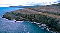
Alladie Cliffs, part of the Burren and Cliffs of Moher Geopark

