
The Burren facts for kids
Quick facts for kids The Burren |
|
|---|---|
| Boireann | |

The karst landscape of the Burren
|
|

The Burren
Location in Ireland
|
|
| Location | Co. Clare (and a little of Co. Galway), Ireland |
| Nearest city | Galway |
The Burren (Irish: Boireann, meaning great rock) is a special area in northwestern County Clare, Ireland. It is famous for its unique landscape, which is mostly made of karst rock. This means the land has been shaped by water dissolving limestone.
The Burren covers between 250 and 560 square kilometers (96 to 216 square miles). It includes towns like Tubber, Corofin, Kilfenora, Lisdoonvarna, Ballyvaughan, and Kinvara.
A small part of the Burren is protected as the Burren National Park. This is the smallest of Ireland's six National Parks. The wider area, including the amazing Cliffs of Moher, is part of the Burren and Cliffs of Moher Geopark.
Contents
Where is The Burren Located?
The Burren is mainly in northwestern Clare. It also stretches into County Galway in the north and northeast. The area is bordered by the Atlantic Ocean and Galway Bay. The Aran Islands are actually a natural extension of the Burren's limestone hills.
The exact size of the Burren can change depending on how you define it. Some definitions include nearby towns like Ennistymon and the Cliffs of Moher. Other definitions stretch the area to include places like Coole Park and the unique turloughs (disappearing lakes).
About 60% of the uplands in the Burren show exposed limestone rock. This creates a very distinct and beautiful landscape.
What is The Burren's Climate Like?
The Burren has a surprisingly mild climate for western Ireland. In July, the average temperature is about 15°C (59°F). In January, it's around 4-6°C (39-43°F). The soil temperature rarely drops below 6°C (43°F).
This means grass can grow for most of the year. The Burren has one of the longest growing seasons in Ireland and Britain. This helps many different plants to grow there.
The area gets a lot of rain, about 1525 mm (60 inches) each year. This is more than double the rainfall in eastern Ireland. The wettest months are from October to January.
Late May is often the sunniest time. It's also a great time to see flowers like gentians and avens blooming.
In the 1600s, a soldier named Edmund Ludlow described the Burren. He said it had "not enough water to drown a man, wood enough to hang one, nor earth enough to bury him." But he also noted that the cattle were very fat because the grass growing between the rocks was "very sweet and nourishing."
The Geology of The Burren


.jpg)
The Burren is made of thick layers of sedimentary rock. These are mostly limestones, but also include sandstones and mudstones. All the rocks you see on the surface formed during the Carboniferous period. This was about 325 million years ago.
The limestones formed from sediments at the bottom of a tropical sea. You can find fossils of corals, crinoids, sea urchins, and ammonites in these rocks. This limestone layer can be up to 800 meters (2,600 feet) thick.
Later, around 318 million years ago, the limestone was covered by sand and mud. These turned into shale and sandstone. These top layers protected the limestone from wearing away for millions of years. Most of these layers were later removed by glaciers. However, some still remain in the southwest.
How Glaciers Shaped The Burren
Glaciers moved across the Burren many times over the last million years. The most recent ice age, called the Midlandian, covered the whole area with ice. This made the Burren one of the best examples of a glaciokarst landscape in the world.
The ice removed older features. So, the rock formations you see today have mostly formed in the last 10,000 years. This makes the Burren's karst features quite new in geological terms.
Water has widened the cracks, called grikes, in the limestone pavement. These grikes are separated by flat slabs of rock called clints. Water also flows underground, creating many cave systems. Over 50 kilometers (31 miles) of caves have been mapped. Aillwee Cave is one of the most famous.
Because of this underground drainage, there are very few permanent rivers on the surface. The Caher River, flowing into the sea at Fanore, is one of the few. Some large valleys you see today are actually old river valleys from before the glaciers.
Another interesting feature is the "polje." These are closed, circular dips in the land where water has no surface outlet. There are about 100 of these, mostly in the eastern Burren. The largest is the Carran depression, which is over two miles long.
Glaciers also left behind large rocks called erratics. These are rocks that were carried by the ice from other places. Granite erratics, for example, were brought from across Galway Bay.
The highest point in the Burren uplands is Slieve Elva, which is about 345 meters (1,132 feet) above sea level.
Types of Landscapes and Habitats
Besides the limestone pavement, the Burren has many other types of landscapes. These include:
- Limestone heath
- Dry grasslands
- Wetlands with springs
- Turloughs (lakes that appear and disappear)
- Bogs
- Lakes
- Scrub and light woodland
These different areas provide homes for a wide variety of plants and animals.
Plants and Animals of The Burren
.jpg)
.jpg)
Amazing Plants
The Burren is famous for its incredible mix of plants and animals. Over 70% of Ireland's flower species can be found here. It's unique because plants from cold, Arctic–alpine regions grow right next to plants from warm Mediterranean areas. This happens because of the unusual environment.
Many rare Irish plant species live only in the Burren. For example, two types of Taraxacum found here are almost unique to the Burren. Also, 23 of the 28 types of orchids in Ireland grow in the Burren.
The grikes (cracks in the limestone) offer moist, sheltered spots. These allow many plants, including small shrubs, to grow. Where the limestone is broken into gravel, you can find hardy Arctic or alpine plants. Patches of grass and other plants grow where there's a thin layer of soil.
A famous flower here is the spring gentian, with its bright blue flowers. It's often used as a symbol for the area. Other notable flowers include the Irish orchid and bloody cranesbill. About 24 types of ferns also thrive in the limestone grikes.
It's amazing that plants that dislike lime and plants that love it grow so close together here. Acid-loving plants, like Calluna, grow on patches of acidic peat. This peat protects them from the limestone below.
Wonderful Animals
Almost all of Ireland's 30-plus species of butterflies and moths live in the Burren. Some special insects found here include the pearl-bordered fritillary butterfly and the Burren green moth. The Burren green moth is only found in Ireland in this area.
The Burren is also a main breeding area in Ireland for the European pine marten. You can also find badgers, foxes, and stoats. Wild goats roam the hillsides. All seven species of bats in Ireland live in the Burren. Otters and grey seals live along the coast. You might even spot porpoises,dolphins and basking sharks near the Cliffs of Moher.
Many bird species call the Burren home. These include crows, ravens, peregrine falcons, kestrels, and various types of gulls. Sea birds like guillemots, razorbills, kittiwakes, fulmars, puffins, and shags are also common.
The History of The Burren

Ancient Times

Long ago, around 8000 to 7000 BC, the Burren looked very different. Most of the uplands were covered in trees. We haven't found clear signs of early human settlements from this time.
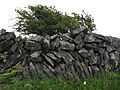
However, by about 4000 BC, people had arrived. They started to change the landscape by cutting down trees, probably by overgrazing and burning. They also built stone walls. These people created large stone monuments called Megalithic sites. One famous example is the Poulnabrone dolmen. There are about 70 such tombs in the Burren, which is more than half of all those found in Clare.
The most common ancient structures are wedge tombs. These date from about 2500 to 2000 BC. Many are found on Roughan Hill. Large stone cairns (piles of stones) on hills, like the Poulawack Cairn, are also from this time.
People back then likely farmed animals in small groups. They moved their cattle to the uplands in winter, which is the opposite of how it's usually done. This allowed them to graze animals all year.
The population of the Burren probably dropped between the late Stone Age and the end of the Bronze Age. This was likely due to a climate change, with cooler and wetter weather. Heavy rain, combined with earlier tree clearing, caused a lot of soil to wash away. This meant less fertile land, which put pressure on the people. Building new stone walls mostly stopped during this time.
Medieval Times


In the Iron Age and early Medieval times, a family or tribe called the Corco Modhruadh controlled the region. They were one of many small tribes in Ireland.
When Christianity arrived in the 5th and 6th centuries, the area had several early church sites. These include Kilfenora, Kilnaboy, Temple Cronan, and the churches of Oughtmama. There are also almost 500 stone forts, called cashels, in the Burren. This shows that many people lived here during the early Medieval period.
Around the 12th century, Cistercian monks built Sancta Maria de Petra Fertili, now known as Corcomroe Abbey. The area was also divided into two parts for administration. These later became the English Baronies of Corcomroe and Burren.
The end of the Medieval period was hard. Like much of Europe, the area suffered from the Great Famine and the Black Death. Also, fighting between local leaders caused problems.
Early Modern Times
The Anglo-Normans didn't have much direct impact on the Burren for a long time. Local clans even fought against a Norman army in 1318. People continued to live in fortified houses, often inside cashels, and kept their Gaelic culture.
In the 15th and 16th centuries, many tower houses were built. Examples include Newtown Castle and Doonagore Castle. These castles were often built near the borders of clan territories.
The O'Loughlin clan ruled the Boireann area from Gregans Castle until the mid-1600s. Their relatives, the O'Conor clan, ruled the western part. Both clans were under the control of the O'Briens, who ruled Thomond.
Culture and Arts
The Burren has a rich history of traditional Irish music. It's especially known for the "West Clare Style" of concertina playing. Music festivals are held in Doolin and Corofin.
The area has also inspired many artists and writers. It has several art galleries. A series of detective fiction novels by Cora Harrison are set in the Burren in the 1500s. They feature a fictional brehon judge, who followed ancient Irish laws.
Economic Activities
The main ways people make a living in the Burren are through farming and tourism.
Tourism in The Burren
The Burren is well-known beyond Ireland. People from many countries visit to see the Cliffs of Moher, famous show caves, and ancient dolmens like Poulnabrone dolmen. There are many places to stay, like hotels and bed and breakfasts.
Tourism can be a challenge for such a sensitive environment. It creates mostly seasonal jobs and can put a strain on natural resources. This has led to the growth of ecotourism and "Leave No Trace" campaigns. These efforts help protect the landscape while still allowing visitors to enjoy it.
Ecotourism: Protecting Nature While Visiting
Ecotourism is very important in the Burren. Many groups work to protect the fragile landscape. At the same time, they want to ensure local people earn a fair income and that the area can handle more visitors. Sustainable ecotourism aims to balance these needs.
Food Tourism: A Taste of The Burren
The Burren Food Trail started in 2013. It has many businesses offering local food and drink. The trail won an award in 2015 for its focus on tourism and local food. Events like a Slow Food festival and a Food Fayre are also held.
Farming in The Burren
The Burren has a long history of farming. This is thanks to its climate, landscape, and traditional methods. Growing crops is limited, so the main animals raised are cattle and goats.
Traditionally, farmers moved hardy cattle to the uplands in winter. This allowed them to graze year-round and kept the land healthy. This method also helped protect the unique landscape.
Farming Challenges
In recent times, modern farming methods have created new challenges. These include using too much fertilizer and changing limestone pavement into pasture. Research shows that a lot of the limestone pavement has been lost since the 1840s.
The number of farmers has also dropped, and farms have become larger. Another problem is the spread of brush, like hazel. This happens because fewer cattle and goats graze the land in winter. This reduces the variety of plants and animals in the affected areas.
BurrenLIFE Program
To help with these challenges, the BurrenLIFE program started a new farming plan. It worked with farmers to create specific plans for their farms. These plans included clearing brush, fixing stone walls, and returning to winter grazing. This helps keep the landscape healthy and supports local farming traditions.
Balancing Needs in The Burren
For many years, the government and private groups have tried to balance the needs of farmers, tourists, and the environment. For example, old septic tanks in rural houses can harm underground water. Proper sewage treatment is still needed in many areas.
Local Development Efforts
Many community and local government programs have been launched. These include Burren Connect, which led to the Geopark in 2011. Other groups like the Burrenbeo Trust and the Burren Ecotourism Network also work to support the area.
Special Protected Areas
Most of the Burren is now a Special Area of Conservation. This includes most of the uplands and coastal areas. There are also Areas of Scientific Interest and Natural Heritage Areas.
Burren and Cliffs of Moher Geopark
The Burren and Cliffs of Moher Geopark was created in 2011. It is part of the Global Geoparks Network (GGN) and recognized by UNESCO. The Geopark includes a large part of the Burren and the Cliffs of Moher. It helps with education, community involvement, and sustainable tourism.
Burren National Park
The Burren National Park is one of Ireland's six National Parks. It covers about 1500 hectares (3,700 acres) in the southeastern Burren. The Irish government bought this land to protect it. The National Park has an information point in Corofin.
Sports and Fun Activities
The Burren's limestone cliffs, especially at Ailladie, are popular for rock-climbing. For cavers, there are many mapped caves, like Pollnagollum. Doolin is a popular place for cavers to stay.
The Burren is also great for walkers. The Burren Way is a popular trail that often takes five days to complete. The Cliffs of Moher Coastal Walk is 18 kilometers (11 miles) long.
The Burren also has local Gaelic Athletic Association clubs and soccer clubs. While the landscape makes it hard to maintain golf courses, there are facilities near Gort and Lahinch.
Gallery
-
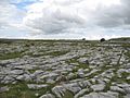
The Burren landscape
-
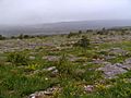
Karst meadow
-
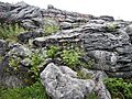
Native flowers and rock formations
-
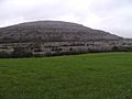
Karst dome near Kilkeedy Parish - eastern part of The Burren
-
The Burren fence


See also
 In Spanish: El Burren para niños
