Butte Lake (California) facts for kids
Quick facts for kids Butte Lake |
|
|---|---|
 |
|
| Location | Lassen Volcanic National Park Lassen County, California |
| Coordinates | 40°33′44″N 121°17′23″W / 40.562108°N 121.289694°W |
| Type | Lake |
| Primary inflows | Butte Creek |
| Basin countries | United States |
| Surface elevation | 1,845 m (6,053 ft) |
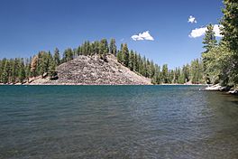
Butte Lake is a beautiful lake located in the northeastern part of Lassen Volcanic National Park. This park is in the U.S. state of California. The lake sits high up, at an elevation of about 1,845 meters (6,053 feet). It's a great spot to visit and learn about volcanoes and nature.
What is Butte Lake Like?
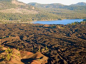
The lake has an interesting, uneven shape. It is found at the northern end of an area called the Cinder Cone and the Fantastic Lava Beds. This area has many lava flows and a special type of volcano called a cinder cone.
Around the mid-1770s, lava from the Cinder Cone flowed into and around Butte Lake. This created a unique underwater lava field. Water from Snag Lake, which is to the south, flows through this porous lava field to reach Butte Lake. Water then leaves Butte Lake through Butte Creek. This creek flows north out of the park.
How to Visit Butte Lake
If you want to visit Butte Lake, there is a campground and a ranger station. They are located on the west side of the lake. You can get to Butte Lake by driving on an unpaved road. This road branches off from California Route 44. Sometimes, this unpaved road closes during certain seasons, like winter.
See also
 In Spanish: Lago Butte para niños
 | Laphonza Butler |
 | Daisy Bates |
 | Elizabeth Piper Ensley |


