Byer, Ohio facts for kids
Quick facts for kids
Byer, Ohio
|
|
|---|---|

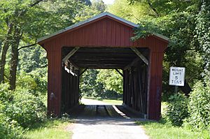
Byer Covered Bridge
|
|
| Country | United States |
| State | Ohio |
| Counties | Jackson |
| Elevation | 637 ft (194 m) |
| Time zone | UTC-5 (Eastern (EST)) |
| • Summer (DST) | UTC-4 (EDT) |
| ZIP code |
45692
|
| Area code(s) | 740 |
| GNIS feature ID | 1056746 |
Byer is a small, unincorporated community in Jackson County, Ohio, United States. An unincorporated community means it's a place where people live, but it doesn't have its own local government like a city or town. It is located in the northwestern part of Washington Township. You can find Byer along State Route 327, which is a road that connects Wellston and Londonderry.
The Story of Byer
How Byer Got Its Name
Before the Civil War, this area was called Ellsworth. Later, its name was changed to Byers Station. This new name honored the Byers family, who owned land in the area.
The Byers Station Post Office opened on June 5, 1871. On November 29, 1882, the town's name was shortened to Byer. The post office also closed on that same day. Today, mail service for Byer is handled by the Wellston branch.
Byer Covered Bridge
One of the most interesting landmarks in Byer is the Byer Covered Bridge. This historic bridge was built in 1870. It is a special part of the community's history. The bridge is so important that it is listed on the National Register of Historic Places. This means it is recognized as a place worth protecting for its historical value.
Local Geography
A small waterway called Pigeon Creek runs along the western edge of Byer. This creek eventually flows into the Scioto River through Salt Creek.
 | Laphonza Butler |
 | Daisy Bates |
 | Elizabeth Piper Ensley |


