Byers island facts for kids
Lua error in Module:Coordinates at line 614: attempt to index field 'wikibase' (a nil value).
Byers Island is a famous example of a phantom island. A phantom island is a piece of land that once appeared on maps but was later found not to exist. This particular island was supposedly discovered by a sea captain named Benjamin Morrell in 1825.
Contents
What is Byers Island?
Byers Island was an island that Captain Benjamin Morrell claimed to have found on July 12, 1825. He wrote about this "discovery" in his book, A Narrative of Four Voyages. Morrell said the island was located at 28 degrees 32 minutes North and 177 degrees 4 seconds East. This spot is in the Pacific Ocean, northwest of Hawaii.
Why is it a Phantom Island?
Even though Captain Morrell wrote about Byers Island, it doesn't actually exist. We know this because he had just visited a real place called Pearl and Hermes Reef and gave its exact location. This means he couldn't have mistaken Byers Island for another nearby real island like Kure Atoll, because he knew where Kure was too.
The Mystery of the Missing Island
The name "Byers" came from the owner of Morrell's ship, who was also one of his bosses. This is a clue that Morrell might have made up the island. Some historians believe that Morrell's book had a ghostwriter named Samuel Woodworth. A ghostwriter is someone who writes a book for another person, but the other person gets the credit.
Even if Morrell didn't write every word himself, he likely knew that some parts of his book were not true. He probably allowed these false stories to be included to make his book more exciting and sell more copies.
Byers Island on Maps
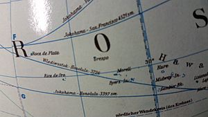
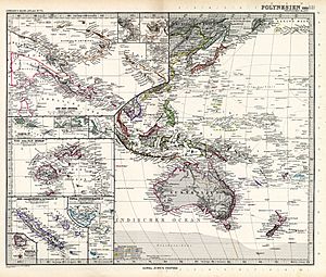
Even though Byers Island was a fake, it appeared on maps and globes for many years. By 1899, official sailing guides already listed Byers Island as "doubtful." This meant they weren't sure if it was real. However, some globes from the 1960s still showed Byers Island. It was often shown with other phantom islands northwest of Kure Atoll. This shows how long it took for these made-up places to be completely removed from maps.


