
Byromville, Georgia facts for kids
Quick facts for kids
Byromville, Georgia
|
|
|---|---|

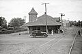
Byromville city limit on GA90
|
|

Location in Dooly County and the state of Georgia
|
|
| Country | United States |
| State | Georgia |
| County | Dooly |
| Area | |
| • Total | 0.36 sq mi (0.94 km2) |
| • Land | 0.36 sq mi (0.94 km2) |
| • Water | 0.00 sq mi (0.00 km2) |
| Elevation | 381 ft (116 m) |
| Population
(2020)
|
|
| • Total | 422 |
| • Density | 1,165.75/sq mi (450.17/km2) |
| Time zone | UTC-5 (Eastern (EST)) |
| • Summer (DST) | UTC-4 (EDT) |
| ZIP code |
31007
|
| Area code(s) | 478 |
| FIPS code | 13-12232 |
| GNIS feature ID | 0354929 |
Byromville is a small town located in Dooly County, Georgia, in the United States. In 2010, about 546 people lived there. By 2020, the population was 422.
Contents
History of Byromville
Byromville became an official town in 1905. This happened when the Georgia General Assembly (which is like Georgia's state government) made it a town. The town was named after an important early resident, William H. Byrom.
Geography and Location
Byromville is in the northwestern part of Dooly County. You can find its exact spot using these coordinates: 32.201496 degrees North and 83.908028 degrees West.
How to Get Around Byromville
Georgia State Route 90 goes right through the middle of Byromville. This road can take you about 11 miles (18 km) southeast to Vienna, which is the main town of Dooly County. If you go about 10 miles (16 km) northwest, you'll reach Montezuma.
Another road, SR 230, goes northeast from Byromville for about 12 miles (19 km) to Unadilla. If you head southwest on SR 230 for about 10 miles (16 km), you'll connect with SR 27 in a place called Drayton.
Size of the Town
The United States Census Bureau says that Byromville covers a total area of about 0.36 square miles (0.94 square kilometers). All of this area is land, meaning there are no large lakes or rivers within the town limits.
Population Changes Over Time
The number of people living in Byromville has changed over the years. Here's a look at how the population has grown and shrunk:
| Historical population | |||
|---|---|---|---|
| Census | Pop. | %± | |
| 1910 | 300 | — | |
| 1920 | 414 | 38.0% | |
| 1930 | 315 | −23.9% | |
| 1940 | 275 | −12.7% | |
| 1950 | 288 | 4.7% | |
| 1960 | 349 | 21.2% | |
| 1970 | 419 | 20.1% | |
| 1980 | 567 | 35.3% | |
| 1990 | 452 | −20.3% | |
| 2000 | 415 | −8.2% | |
| 2010 | 546 | 31.6% | |
| 2020 | 422 | −22.7% | |
| 2023 (est.) | 335 | −38.6% | |
| U.S. Decennial Census | |||
Arts and Culture in Byromville
Byromville is known for hosting a fun event each year called the Turkey Creek Festival. It's a time when the community comes together to celebrate.
See also
 In Spanish: Byromville (Georgia) para niños
Images for kids
-
Byromville train station around 1939

