Caburgua-Huelemolle facts for kids
Quick facts for kids Caburgua-Huelemolle |
|
|---|---|

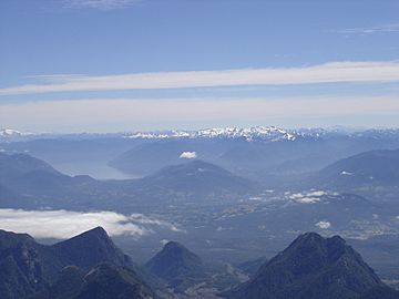
Some of the cinder cones are visible in the middle distance. The ice-capped Nevados de Sollipulli in the distance as seen from Villarrica Volcano. Also visible in the image is Caburgua Lake.
|
|
| Highest point | |
| Elevation | 1,496 m (4,908 ft) |
| Geography | |
| Location | Chile |
| Parent range | Andes |
| Geology | |
| Mountain type | Cinder cones |
| Last eruption | 5050 BC ± 1000 years |
Caburgua-Huelemolle is a fascinating volcanic area in Chile. It's not just one big volcano, but a collection of four main groups of small volcanoes. These small volcanoes are called cinder cones. They look like cone-shaped hills made from volcanic ash and rock pieces.
The four main groups of cinder cones in Caburgua-Huelemolle are:
- Volcanes de Caburgua
- Volcán Huelemolle
- Volcán Redondo
- Pichares
The Volcanes de Caburgua group has six cinder cones. You can find them at the southern end of Caburgua Lake. This lake was actually created by lava from these volcanoes! The lava flowed and blocked a river, forming the lake. Volcán Huelemolle is another group with three cinder cones. These are located between the Liucura and Trancura rivers.
Contents
What are Cinder Cones?
Cinder cones are the simplest type of volcano. They are built from pieces of lava that are blown into the air from a volcanic vent. As these pieces, called cinders, fall back to the ground, they pile up around the vent. This creates a circular or oval cone shape. They usually have a bowl-shaped crater at the top. Cinder cones are often found on the sides of larger volcanoes or in groups like Caburgua-Huelemolle.
When Did Caburgua-Huelemolle Last Erupt?
The last known eruption from the Caburgua-Huelemolle volcanic system happened a very long time ago. Scientists estimate it was around 5050 BC, give or take about 1000 years. This means these volcanoes have been quiet for thousands of years.
Where is Caburgua-Huelemolle Located?
This volcanic area is found in Chile, a country in South America. It's part of the Andes mountain range, which runs along the western side of the continent. The coordinates for Caburgua-Huelemolle are 39°15′0″S 71°42′0″W. This helps scientists and explorers pinpoint its exact location on a map.
See also
 In Spanish: Complejo volcánico Caburgua-Huelemolle para niños
- List of volcanoes in Chile
 | Janet Taylor Pickett |
 | Synthia Saint James |
 | Howardena Pindell |
 | Faith Ringgold |

